Reson 8101ER Multibeam Sonar Data from Cruise AHI0605 - Main Hawaiian Islands
Reson 8101ER multibeam Data were collected in
19-24 April and 28 April-11 May 2006 aboard NOAA Survey
Launch Acoustic Habitat Investigator (AHI) in the Main
Hawaiian Islands at Penguin Bank, N. Shore Molokai,
Lanai, and the Big Island of Hawaii during
cr...
CRED Acoustic Backscatter Tinian, Commonwealth of Northern Mariana Islands (CNMI) 2003, Imagery Extracted from Gridded Bathymetry
Backscatter extracted from gridded bathymetry of the banktops and shelf environments of the Tinian, of the
Commonwealth of Northern Mariana Islands (CNMI).
CRED Acoustic Backscatter Manua Islands, American Samoa 2004; Imagery Extracted from Gridded Bathymetry of the Surrounding Banktop and Slope Environments
Backscatter extracted from gridded bathymetry of the banktops and slope of Ofu and Olosega Islands of the
Manu'a Island group, American Samoa. This survey provides almost complete coverage between 20 and 250 meters.
Reson 8101ER Multibeam Sonar Data from Cruise AHI1009 - Main Hawaiian Islands, Kaneohe Bay, Windward Side Oahu
Reson 8101ER multibeam Data were collected in
September 30 - October 10, 2010 aboard NOAA Survey
Launch Acoustic Habitat Investigator (AHI) at Kaneohe Bay and
Windward Side of Oahu, Main Hawaiian Islands during
cruise AHI1009. These multibeam data were c...
Reson 8101ER Multibeam Sonar Data from Cruise AHI1012 - Oahu, Main Hawaiian Islands
Reson 8101ER multibeam Data were collected on
December, 13 and December, 14, 2010 aboard NOAA Survey
Launch Acoustic Habitat Investigator (AHI) in the Main
Hawaiian Islands at Oahu during
cruise AHI1012. These multibeam data were collected
using SAIC ISS...
Reson 8101ER Multibeam Sonar Data from Cruise AHI1502 - Oahu, Main Hawaiian Islands
Reson 8101ER multibeam Data were collected on
April 24, 2015 aboard NOAA Survey
Launch Acoustic Habitat Investigator (AHI) in the Main
Hawaiian Islands at Oahu during
cruise AHI1502. These multibeam data were collected
using SAIC ISS-2000 v 4.0.0.3.0 so...
 CRED Cumulative Map of Percent Scleractinian Coral Cover at Necker Island, 2002-2004
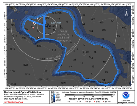 This map displays optical validation observation locations and percent coverage of scleractinian coral overlaid on bathymetry.
 Reson 8101ER Multibeam Sonar Data from Cruise AHI0605 - Main Hawaiian Islands