
Orthophoto Mosaic (2012) for Coral Bay, St. John
This 0.3x0.3 meter imagery mosaic of Coral Bay, St. John in the U.S. Virgin Islands was created by the National Oceanic and Atmospheric Administration (NOAA) using a collection of orthophotos collected by the U.S. Army Corps of Engineers in 2012. This col...
Pacific Reef Assessment and Monitoring Program: Calcification Rates of Crustose Coralline Algae Derived from Calcification Accretion Units (CAUs) Deployed across American Samoa and the Pacific Remote Island Areas in 2010

Calcification accretion units, or CAUs, are used to assess the current effects of changes in seawater carbonate chemistry on calcification and accretion rates of calcareous and fleshy algae in the Hawaiian and Mariana Archipelagos, American Samoa, and the...
2007 Palm Beach County Essential Fish Habitat Mapping of Seagrass, Mangroves, Oysters, and Spartina in estuarine waters. (NODC Accession 0061752)
2007 Palm Beach County Mapping Project photointerpreted from June 20 & 22, July 21, and August 4 & 8, 2007 1:10,000 scale and July 1, 2007 1:4,800 scale natural color aerial photography of the entire Lake Worth Lagoon system and the ICW throughout Palm Be...
2007 Palm Beach County Orthorectified photos of the County's estuarine waters including the Lake Worth Lagoon. Used for mapping essential fish habitat (NODC Accession 0061752)
2007 Palm Beach County Mapping Digital Orthorectified photos and Mosaics of 1:10000 scale natural color aerial photography were created. Imagery was flown on June 20 & 22, July 21, and August 4 & 8, 2007. Additionally, there was 1:4800 scale natural co...
 Gridded bathymetry at 40m resolution surrounding Baker Island, within the Pacific Remote Island Areas - Central Pacific Ocean. Bottom coverage was achieved in depths between 8 and 4700 meters. The Arc ASCII grids and floating point geotifs include multibe...
 Gridded bathymetry at 40m resolution surrounding Howland Island, within the Pacific Remote Island Areas - Central Pacific Ocean. Bottom coverage was achieved in depths between 8 and 3800 meters. The Arc ASCII grids and floating point geotifs include multi...
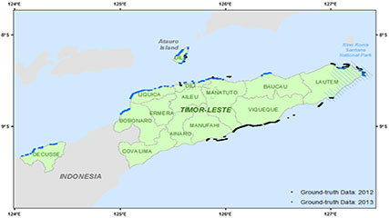 This dataset contains singlebeam bathymetry data acquired during small-boat surveys conducted from October 20-26, 2012 and June 4-27, 2013 in Timor-Leste by the NOAA Coral Reef Ecosystem Program (CREP). Data was acquired with a HydroLite-TM Echosounder Ki...
 Calcification accretion units, or CAUs, are used to assess the current effects of changes in seawater carbonate chemistry on calcification and accretion rates of calcareous and fleshy algae in the Hawaiian and Mariana Archipelagos, American Samoa, and the...
 Leading Edge Geomatics (LEG) collected 3451 square miles in Puerto Rico. The nominal pulse spacing for this project was 1 point every 0.7 meters. Dewberry used proprietary procedures to classify the LAS according to project specifications: 0-Never Class...
 The focus of the Wahikuli-Honokowai Watershed Management Plan is the land use practices and alterations affected in the agricultural and urban districts that have upset the natural drainage patterns and ecohydrologic balance and services the watersheds pr...