
Satellite-derived bathymetry for nearshore benthic habitats in the Pacific Remote Islands Marine National Monument
Bathymetric data derived from multispectral, high-resolution (2 m) satellite imagery acquired between 2011 and 2016 from Digital Globe’s WorldView-2 or WorldView-3 satellite to provide near complete coverage of nearshore terrain around several islands and...
Benthic Habitat Maps for Rose Atoll Marine National Monument in American Samoa from 2004 to 2010
Benthic habitat maps for Rose Atoll, American Samoa were derived from high resolution, multispectral satellite imagery for 2004, 2006, and 2010. The benthic habitat maps for 2004 were previously generated by NOAA's NCCOS's BioGeography Branch before this ...
Linkages between reef fish demographics and benthic habitat characteristics in Tutuila, American Samoa and Main Hawaiian Islands
Benthic habitats play vital roles in the distribution and abundances of marine resources. Understanding how fish populations respond to variability of benthic habitat characteristics is essential for effective coral reef management and monitoring. A pilot...
Eco-spatial data layers of coral reef ecosystem drivers in American Samoa
Understanding the spatial distribution, intensity, overlap, and cumulative impact of human activities and environmental stressors is essential for effective management and protection of ecosystem services generated by coral reefs. The data described here ...
Seafloor substrate (hard and soft bottom) maps at select islands/atolls in American Samoa, Mariana Archipelago, and the Pacific Remote Island Areas

Seafloor substrate (i.e., hard vs. soft bottom) from 0 to up to 50 m depths around islands/atolls in American Samoa, Mariana Archipelago, and Pacific Remote Island Areas produced by the NOAA Ecosystem Sciences Division (ESD). The islands/atolls include Tu...
2003 U.S. Geological Survey (USGS) Experimental Advanced Airborne Research Lidar (EAARL): US Virgin Islands (St. John, St. Croix)
This data set contains topographic and bathymetric lidar data that were collected on April 21, 23, 30, May 2, and June 14, 17 of 2003,
cooperatively by the U.S. Geological Survey (USGS), National Aeronautics and Space Administration (NASA), and National P...
 Gridded bathymetry at 60m resolution surrounding Guam Island, Guam U.S. Territory. Bottom coverage was achieved in depths between 0 and ~3500 meters. The Arc ASCII grids and floating point geotifs include multibeam bathymetry data acquired over multiple s...
 Declining health of coral reef ecosystems led scientists to search for factors that support reef resilience: the ability of reefs to resist and recover from environmental disturbance. Scientists recently identified 11 measurable factors that affect the re...
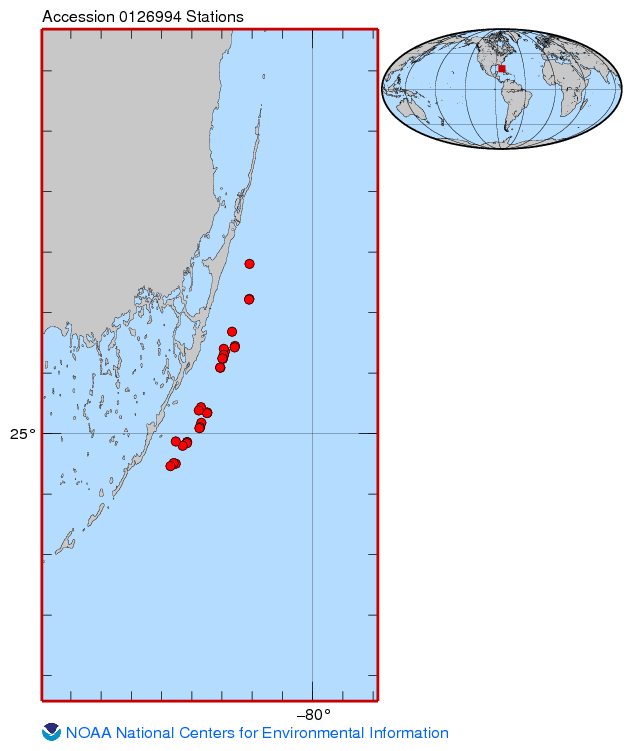 Temperature loggers were deployed at various monitoring sites off the upper Florida Keys where other ecological studies were underway, most focused on aspects of Acropora spp. status or ecology. Hobo Pendant loggers were secured to the substrate at a site...
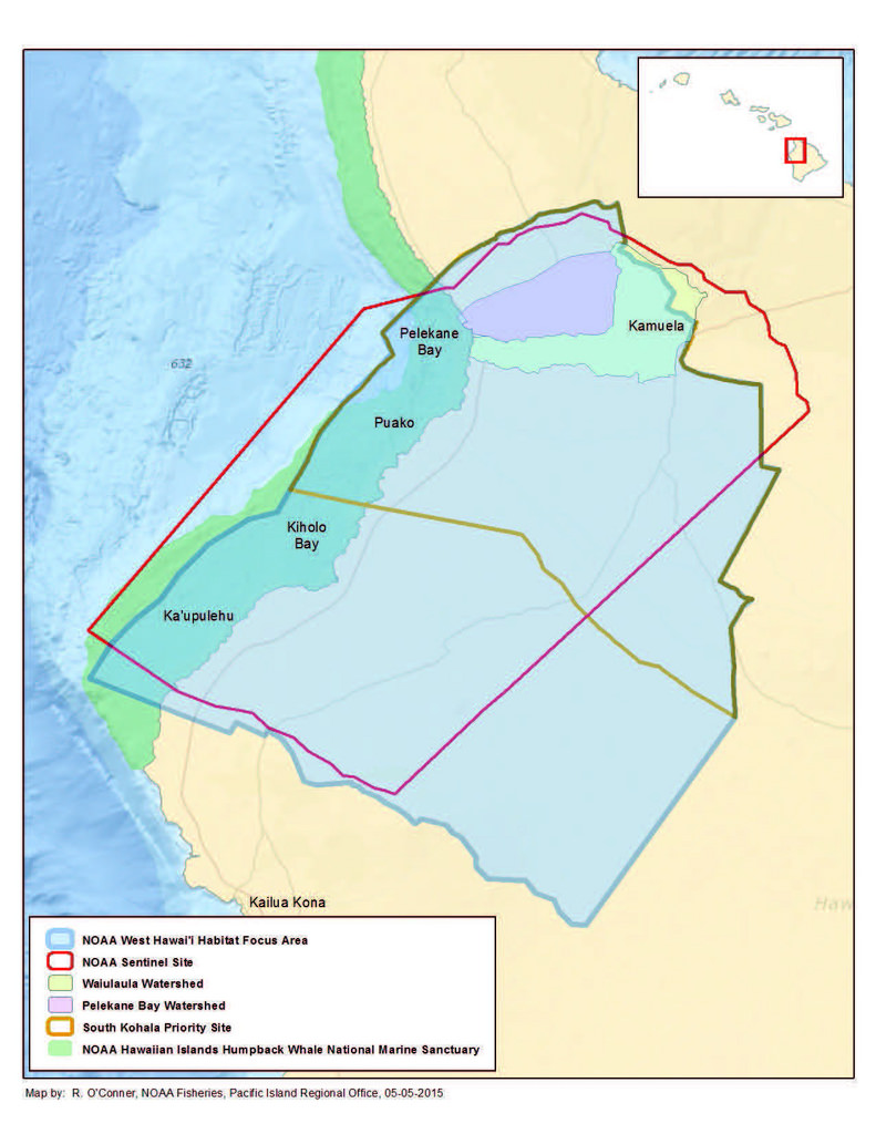 Benthic habitat maps depict dominant substrate type and biological cover in depths between 0 and ~150 m for two priority sites in the Main Hawaiian Islands; the NOAA Habitat Blueprint West Hawaii Focus Area (WHFA) and the Hawaii Division of Aquatic Resour...
 Seafloor substrate (i.e., hard vs. soft bottom) from 0 to up to 50 m depths around islands/atolls in American Samoa, Mariana Archipelago, and Pacific Remote Island Areas produced by the NOAA Ecosystem Sciences Division (ESD). The islands/atolls include Tu...