Citation:
Citation_Information:
Originator:
Pacific Islands Benthic Habitat Mapping Center (PIBHMC), Coral Reef Ecosystem Division (CRED), Pacific Islands Fisheries Science Center (PIFSC), National Marine Fisheries Service (NMFS), National Oceanic and Atmospheric Administration (NOAA)
Publication_Date: 20110729
Title:
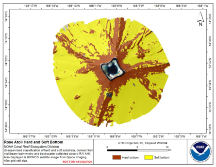
Preliminary hard and soft bottom seafloor substrate map (40m grid) derived from an unsupervised classification of gridded backscatter and bathymetry derivatives at Rose Atoll, Territory of American Samoa, USA.
Geospatial_Data_Presentation_Form: digital data
Online_Linkage: http://www.soest.hawaii.edu/pibhmc/
Online_Linkage:
Description:
Abstract:
Preliminary hard and soft seafloor substrate map derived
from an unsupervised classification of multibeam backscatter and
bathymetry derivatives at Rose Atoll, Territory of American Samoa, USA.
The dataset was created from gridded (40 m cell size) multibeam bathymetry derivatives collected
aboard R/V AHI; 2 scales of bathymetric variance and bathymetric rugosity, and from multibeam backscatter.
Backscatter data were from a 30 kHz Simrad EM300 sonar, gridded at 5 m.
Very limited seafloor photographs for groundtruthing are available for Rose Atoll and therefore
no supervised classification was performed and we are unable to
visually or empirically evaluate the accuracy of the unsupervised
classification seafloor substrate map. However, in locations such
French Frigate Shoals, NWHI and Tutuila, American Samoa, where ground
truth data are available, the unsupervised classification method is a
robust predictor of substrate type in similar depth ranges and seafloor
environments.
Since groundtruthing was not used to validate the unsupervised classification at
Rose Atoll extreme caution should be used when examining these data to locate
habitat of biological significance. The map should be used in conjunction with
bathymetric derivatives such as rugosity, slope, and Bathymetric Position Index (BPI).
Purpose:
The hard and soft seafloor map is being used to improve
sampling techniques for long-term ecosystem monitoring, to guide
future ground-truthing operations and to identify coral-rich and
species specific environments. This is a preliminary product and
the methods used to generate the map are currently being evaluated
for their accuracy.
Supplemental_Information:
Gridded multibeam data were collected aboard the NOAA Ship Hi'ialakai, a 218 ft United States
National Oceanographic and Atmospheric Administration research ship.
The process for deriving the 40-m gridded multibeam bathymetry is described
in Rose_40m.asc.txt, available on www.soest.hawaii.edu/pibhmc.
The resulting grid (rose_40m.grd) was clipped using the ESRI ArcToolbox tool 'Extract by Mask'
leaving only the multibeam data collected on the slopes surrounding the atoll and excluding the
discontinuous data around the base of the slopes.
Classification was carried out using this clipped dataset.
Finer resolution data were available for within the lagoon, and these were classified separately (Rose_5m_hardsoft.jpg).
and are also available on www.soest.hawaii.edu/pibhmc. The metadata for the lagoon hard-soft
classification can be seen at Rose_5m_hardsoft.txt. The process for deriving the 5-m gridded multibeam backscatter
is described in rose-em300-bs-5m.grd.txt. Prior to classification the backscatter data were re-gridded
at 40-m using the resample tool in the Arc Toolbox.
The 40-m rugosity and bathymetric variance grids were generated for use in the classification process
and are not served separately. See the process description portion of this document
for additional informaiton about how the variance and unsupervised layers were derived.
Time_Period_of_Content:
Time_Period_Information:
Range_of_Dates/Times:
Beginning_Date: 20060210
Ending_Date: 20060313
Currentness_Reference: ground condition
Status:
Progress: Complete
Maintenance_and_Update_Frequency: As needed
Spatial_Domain:
Bounding_Coordinates:
West_Bounding_Coordinate: -168.176635
East_Bounding_Coordinate: -168.131605
North_Bounding_Coordinate: -14.525078
South_Bounding_Coordinate: -14.563367
Keywords:
Theme:
Theme_Keyword_Thesaurus: NCEI Geoportal Filter
Theme_Keyword: CoRIS_Metadata
Theme:
Theme_Keyword_Thesaurus: CRCP Project
Theme_Keyword:
Benthic Habitat Mapping and Characterization - American Samoa and the U.S. Pacific Remote Island Area
Theme_Keyword: 1084
Theme:
Theme_Keyword_Thesaurus: CoRIS Theme Thesaurus
Theme_Keyword:
EARTH SCIENCE > Oceans > Coastal Processes > Coral Reefs > Coral Reef Ecology > Habitats
Theme_Keyword:
EARTH SCIENCE > Oceans > Coastal Processes > Coral Reefs > Coral Reef Ecology > Rugosity
Theme_Keyword:
EARTH SCIENCE > Biosphere > Zoology > Corals > Reef Monitoring and Assessment > Mapping
Theme_Keyword:
EARTH SCIENCE > Biosphere > Zoology > Corals > Reef Monitoring and Assessment > Mapping > geomorphology Mapping
Theme_Keyword:
EARTH SCIENCE > Biosphere > Zoology > Corals > Reef Monitoring and Assessment > Mapping > Habitat Mapping
Theme:
Theme_Keyword_Thesaurus: CoRIS Discovery Thesaurus
Theme_Keyword: Geographic Information > Habitats
Theme:
Theme_Keyword_Thesaurus: ISO 19115 Topic Category
Theme_Keyword: imageryBaseMapsEarthCover
Theme_Keyword: 010
Place:
Place_Keyword_Thesaurus: CoRIS Place Thesaurus
Place_Keyword:
OCEAN BASIN > Pacific Ocean > American Samoa > Rose Atoll (14S168W0001)
Place_Keyword:
COUNTRY/TERRITORY > United States of America > American Samoa > American Samoa > Rose Atoll (14S168W0001)
Place:
Place_Keyword_Thesaurus: CoRIS Region
Place_Keyword: AmSam
Access_Constraints: None
Use_Constraints:
These data are not to be used for navigation purposes. Please acknowledge the NOAA Pacific Islands Fisheries
Science Center (PIFSC) Coral Reef Ecosystem Division (CRED) and
the Pacific Islands Benthic Habitat Mapping Center (PIBHMC), and
the Joint Institute for Marine and Atmospheric Research (JIMAR)
and School of Ocean and Earth Science and Technology (SOEST),
University of Hawaii as the sources of this information.
Point_of_Contact:
Contact_Information:
Contact_Organization_Primary:
Contact_Organization:
Pacific Islands Benthic Habitat Mapping Center (PIBHMC), Coral Reef Ecosystem Division (CRED), Pacific Islands Fisheries Science Center (PIFSC), National Marine Fisheries Service (NMFS), National Oceanic and Atmospheric Administration (NOAA)
Contact_Address:
Address_Type: mailing and physical address
Address: NOAA IRC
Address: NMFS/PIFSC/CRED
Address: 1845 WASP Blvd., Building 176
City: Honolulu
State_or_Province: HI
Postal_Code: 96818
Contact_Voice_Telephone: 808 725-5360
Contact_Facsimile_Telephone: 808 725-5429
Contact_Electronic_Mail_Address: nmfs.pic.credinfo@noaa.gov
Contact_Instructions: e-mail preferred
Browse_Graphic:
Browse_Graphic_File_Name:
Browse_Graphic_File_Description: Hard and Soft Seafloor Substrate
Browse_Graphic_File_Type: JPEG, PDF
Data_Set_Credit: PIBHMC, CRED, PIFSC, NOAA, and JIMAR
Security_Information:
Security_Classification_System: Not applicable
Security_Classification: Unclassified
Security_Handling_Description: Not applicable