CRED Cumulative Map of Percent Scleractinian Coral Cover at Farallon de Pajaros (Uracas)

Metadata also available as - [Outline] - [Parseable text] - [XML]

Frequently anticipated questions:


What does this data set describe?

Title:
CRED Cumulative Map of Percent Scleractinian Coral Cover at Farallon de Pajaros (Uracas)
Abstract:
This map displays optical validation observation locations and percent coverage of scleractinian coral overlaid on bathymetry.
Supplemental_Information:
Farallon de Pajaros (Uracas) is an active volcano, with a land area of 2.1 square km. A major eruption and lava flow in 1943 affected coastal habitats. Very steep, sloping, boulder habitats surround Farallon de Pajaros, but provide little suitable habitat for corals. The reef is most developed on the southwest (leeward) side. Farallon de Pajaros was found to have the highest density of large predatory fish in the northern islands based on the MARAMP surveys. Farallon de Pajaros is protected from development by the CNMI Constitution and has been declared a wildlife conservation area. Although Farallon de Pajaros translates to "the Island of Birds," only those Terns and Noddies that can nest on bare lava have established colonies. Seabird colonies were last surveyed in 1992. TOAD data were not collected in the immediate vicinity of Farallon de Pajaros, but on a pinnacle rising from a submerged limb of the island approximately 19 km (10 nautical miles) to the southeast. Cruises CoRIS Metadata Record Names OES0307 cred_toad_farallon_de_pajaros_oes0307_2003

Resource Description: Digital video images that are geo-referenced to navigation files.

  1. How might this data set be cited?
    Pacific Islands Benthic Habitat Mapping Center (PIBHMC), Coral Reef Ecosystem Division (CRED), Pacific Islands Fisheries Science Center (PIFSC), National Marine Fisheries Service (NMFS), National Oceanic and Atmospheric Administration (NOAA), 200706, CRED Cumulative Map of Percent Scleractinian Coral Cover at Farallon de Pajaros (Uracas).

    Online Links:

  2. What geographic area does the data set cover?
    West_Bounding_Coordinate: 144.88
    East_Bounding_Coordinate: 144.90
    North_Bounding_Coordinate: 20.55
    South_Bounding_Coordinate: 20.53
  3. What does it look like?
    http://www.soest.hawaii.edu/pibhmc/CNMI_images/FDP_toad_445.jpg (JPEG)
    This map displays optical validation observation locations and percent coverage of scleractinian coral overlaid on bathymetry.
  4. Does the data set describe conditions during a particular time period?
    Beginning_Date: 2003
    Ending_Date: 2003
    Currentness_Reference: ground condition
  5. What is the general form of this data set?
    Geospatial_Data_Presentation_Form: digital image
  6. How does the data set represent geographic features?
    1. How are geographic features stored in the data set?
    2. What coordinate system is used to represent geographic features?
  7. How does the data set describe geographic features?

Who produced the data set?

  1. Who are the originators of the data set? (may include formal authors, digital compilers, and editors)
  2. Who also contributed to the data set?
    Benthic Habitat Mapping Group, Coral Reef Ecosystem Division (CRED), Pacific Islands Fisheries Science Center (PIFSC), NOAA
  3. To whom should users address questions about the data?
    Pacific Islands Benthic Habitat Mapping Center (PIBHMC), Coral Reef Ecosystem Division (CRED), Pacific Islands Fisheries Science Center (PIFSC), National Marine Fisheries Service (NMFS), National Oceanic and Atmospheric Administration (NOAA)
    NOAA IRC
    Honolulu, HI

    808 725-5360 (voice)
    808 725-5429 (FAX)
    nmfs.pic.credinfo@noaa.gov
    Contact_Instructions: e-mail preferred

Why was the data set created?

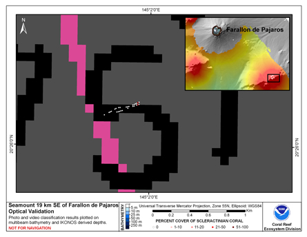
To display locations of optical validation data collected and percent coverage of scleractinian coral at Uracas.

How was the data set created?

  1. From what previous works were the data drawn?
  2. How were the data generated, processed, and modified?
  3. What similar or related data should the user be aware of?

How reliable are the data; what problems remain in the data set?


How can someone get a copy of the data set?

Are there legal restrictions on access or use of the data?
Access_Constraints: None
Use_Constraints:
Please acknowledge the NOAA Coral Reef Ecosystem Division, Pacific Islands Fisheries Science Center as the source of this information.
  1. Who distributes the data set? (Distributor 1 of 1)
    Pacific Islands Benthic Habitat Mapping Center (PIBHMC), Coral Reef Ecosystem Division (CRED), Pacific Islands Fisheries Science Center (PIFSC), National Marine Fisheries Service (NMFS), National Oceanic and Atmospheric Administration (NOAA)
    NOAA IRC
    Honolulu, HI

    808 725-5360 (voice)
    808 725-5429 (FAX)
    nmfs.pic.credinfo@noaa.gov
    Contact_Instructions: e-mail preferred
  2. What's the catalog number I need to order this data set? Downloadable Data
  3. What legal disclaimers am I supposed to read?
    These data are not to be used for navigational purposes. NOAA makes no warranty regarding these data, expressed or implied, nor does the fact of distribution constitute such a warranty. NOAA cannot assume liability for any damages caused by any errors or omissions in these data, nor as a result of the failure of these data to function on a particular system.
  4. How can I download or order the data?

Who wrote the metadata?

Dates:
Last modified: 29-Mar-2020
Last Reviewed: 01-Dec-2009
Metadata author:
Pacific Islands Benthic Habitat Mapping Center (PIBHMC), Coral Reef Ecosystem Division (CRED), Pacific Islands Fisheries Science Center (PIFSC), National Marine Fisheries Service (NMFS), National Oceanic and Atmospheric Administration (NOAA)
NOAA IRC
Honolulu, HI

808 725-5360 (voice)
808 725-5429 (FAX)
nmfs.pic.credinfo@noaa.gov
Contact_Instructions: e-mail preferred
Metadata standard:
FGDC Content Standards for Digital Geospatial Metadata (FGDC-STD-001-1998)

Generated by mp version 2.9.48 on Fri Apr 19 11:00:56 2024