Citation:
Citation_Information:
Originator:
Pacific Islands Benthic Habitat Mapping Center (PIBHMC), Coral Reef Ecosystem Division (CRED), Pacific Islands Fisheries Science Center (PIFSC), National Marine Fisheries Service (NMFS), National Oceanic and Atmospheric Administration (NOAA)
Publication_Date: 200706
Title:
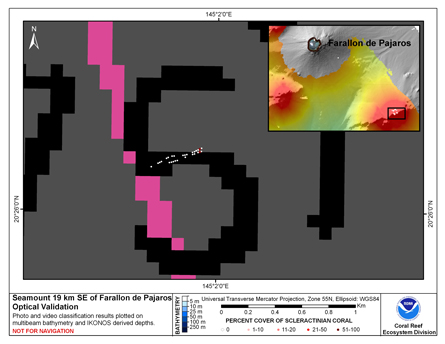
CRED Cumulative Map of Percent Scleractinian Coral Cover at Farallon de Pajaros (Uracas)
Geospatial_Data_Presentation_Form: digital image
Online_Linkage:
Online_Linkage:
Description:
Abstract:
This map displays optical validation observation locations and percent coverage of scleractinian coral overlaid on bathymetry.
Purpose:
To display locations of optical validation data collected and percent coverage of scleractinian coral at Uracas.
Supplemental_Information:
Farallon de Pajaros (Uracas) is an active volcano, with a land area of 2.1 square km. A major eruption and lava flow in 1943 affected coastal habitats. Very steep, sloping, boulder habitats surround Farallon de Pajaros, but provide little suitable habitat for corals. The reef is most developed on the southwest (leeward) side. Farallon de Pajaros was found to have the highest density of large predatory fish in the northern islands based on the MARAMP surveys. Farallon de Pajaros is protected from development by the CNMI Constitution and has been declared a wildlife conservation area. Although Farallon de Pajaros translates to "the Island of Birds," only those Terns and Noddies that can nest on bare lava have established colonies. Seabird colonies were last surveyed in 1992. TOAD data were not collected in the immediate vicinity of Farallon de Pajaros, but on a pinnacle rising from a submerged limb of the island approximately 19 km (10 nautical miles) to the southeast.
Cruises CoRIS Metadata Record Names
OES0307 cred_toad_farallon_de_pajaros_oes0307_2003
Resource Description: Digital video images that are geo-referenced to navigation files.
Time_Period_of_Content:
Time_Period_Information:
Range_of_Dates/Times:
Beginning_Date: 2003
Ending_Date: 2003
Currentness_Reference: ground condition
Status:
Progress: Complete
Maintenance_and_Update_Frequency: As needed
Spatial_Domain:
Bounding_Coordinates:
West_Bounding_Coordinate: 144.88
East_Bounding_Coordinate: 144.90
North_Bounding_Coordinate: 20.55
South_Bounding_Coordinate: 20.53
Keywords:
Theme:
Theme_Keyword_Thesaurus: NCEI Geoportal Filter
Theme_Keyword: CoRIS_Metadata
Theme:
Theme_Keyword_Thesaurus: CRCP Project
Theme_Keyword: Benthic Habitat Mapping and Characterization - CNMI and Guam
Theme_Keyword: 1398
Theme:
Theme_Keyword_Thesaurus: CoRIS Theme Thesaurus
Theme_Keyword: EARTH SCIENCE > Biosphere > Aquatic Habitat > Benthic Habitat
Theme_Keyword:
EARTH SCIENCE > Biosphere > Zoology > Corals > Reef monitoring and assessment > Mapping
Theme:
Theme_Keyword_Thesaurus: CoRIS Discovery Thesaurus
Theme_Keyword: Map Images > Habitats
Theme:
Theme_Keyword_Thesaurus: ISO 19115 Topic Category
Theme_Keyword: environment
Theme_Keyword: 007
Theme_Keyword: biota
Theme_Keyword: 002
Theme:
Theme_Keyword_Thesaurus: None
Theme_Keyword: Synthesis Map
Theme_Keyword: OES0307
Place:
Place_Keyword_Thesaurus: CoRIS Place Thesaurus
Place_Keyword:
OCEAN BASIN > Pacific Ocean > Western Pacific Ocean > Farallon de Pajaros > Farallon de Pajaros (20N144E0001)
Place_Keyword:
COUNTRY/TERRITORY > Northern Mariana Islands > Farallon de Pajaros > Farallon de Pajaros (20N144E0001)
Place:
Place_Keyword_Thesaurus: None
Place_Keyword: Commonwealth of Northern Marianas Islands and Guam
Place:
Place_Keyword_Thesaurus: CoRIS Region
Place_Keyword: CNMI
Access_Constraints: None
Use_Constraints:
Please acknowledge the NOAA Coral Reef Ecosystem Division, Pacific Islands Fisheries Science Center
as the source of this information.
Point_of_Contact:
Contact_Information:
Contact_Organization_Primary:
Contact_Organization:
Pacific Islands Benthic Habitat Mapping Center (PIBHMC), Coral Reef Ecosystem Division (CRED), Pacific Islands Fisheries Science Center (PIFSC), National Marine Fisheries Service (NMFS), National Oceanic and Atmospheric Administration (NOAA)
Contact_Address:
Address_Type: mailing and physical address
Address: NOAA IRC
Address: NMFS/PIFSC/CRED
Address: 1845 WASP Blvd., Building 176
City: Honolulu
State_or_Province: HI
Postal_Code: 96818
Contact_Voice_Telephone: 808 725-5360
Contact_Facsimile_Telephone: 808 725-5429
Contact_Electronic_Mail_Address: nmfs.pic.credinfo@noaa.gov
Contact_Instructions: e-mail preferred
Browse_Graphic:
Browse_Graphic_File_Name:
Browse_Graphic_File_Description:
This map displays optical validation observation locations and percent coverage of scleractinian coral overlaid on bathymetry.
Browse_Graphic_File_Type: JPEG
Data_Set_Credit:
Benthic Habitat Mapping Group, Coral Reef Ecosystem Division (CRED), Pacific Islands Fisheries Science
Center (PIFSC), NOAA
Security_Information:
Security_Classification_System: Not applicable
Security_Classification: Unclassified
Security_Handling_Description: Not applicable