Citation:
Citation_Information:
Originator:
Gaia Geo-Analytical in collaboration with
Davey Jones Locker GIS Laboratory, Oregon State Universtiy for
Coral Reef Ecosystem Division, NOAA Pacific Islands Fisheries
Science Center, Pacific Islands Benthic Habitat Mapping Center
Publication_Date: 20090818
Title:
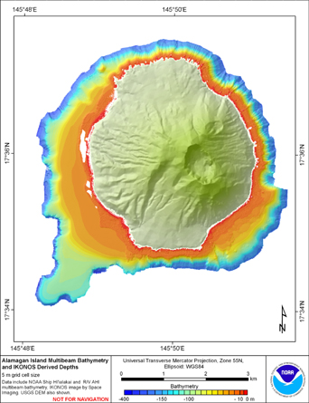
Mosaic of 5 m gridded multibeam bathymetry and bathymetry derived from
multispectral IKONOS satellite imagery of Alamagan Island, Commonwealth of
Northern Mariana Islands, USA
Geospatial_Data_Presentation_Form: raster digital data
Online_Linkage: http://www.soest.hawaii.edu/pibhmc/pibhmc_cnmi_ala_bathy.htm
Description:
Abstract:
Gridded multibeam bathymetry is integrated with bathymetry derived
from multispectral IKONOS satellite data. Gridded (5 m cell size) multibeam
bathymetry collected aboard NOAA Ship Hiialaka'i and R/V AHI. Bathymetry values
shallower than 25 m were derived by gauging the relative attenuation of blue and
green spectral radiance as a function of depth. A multiple linear regression
analysis of linearized blue and green band spectral values against depth
determined the variables of y-intercept, blue slope and green slope values.
Variables then used in multivariate slope intercept formula to derive
depth. Variables were adjusted to improve the statistical accuracy and
spatial coverage of the final derived bathymetry product. Digital image
processing to derive depths conducted with the ENVI 4.5 software program
while data editing and integration was performed using ArcGIS 9.3. This
dataset is for the shelf environment of Alamagan Island, Commonwealth of
Northern Mariana Islands, USA.
Purpose:
The data were derived in support of NOAA Coral Reef Conservation
Program goals. Goal 1 is to map all U.S. Coral Reef Ecosystems.
This data set specifically addresses Objective 1 and 4: to develop
high-resolution benthic maps and to characterize priority deep
water reefs and associated habitats. This integration of derived
bathymetry with multibeam sonar data provides a GIS layer with
expanded spatial coverage that may be used for benthic and essential
fish habitat characterization, and for the study of geologic features.
By combining the dataset with other bathymetry, backscatter, derivatives,
and in situ data, they collectively compose benthic habitat maps
designed to be used to understand and predict shallow depth (0m to 150m)
benthic habitats for organisms that inhabit coral reef ecosystems.
Supplemental_Information:
Gridded multibeam data were collected aboard the Hi'ialakai, a 218'
United States National Oceanographic and Atmospheric Administration
(NOAA) research ship, and aboard the R/V AHI (Acoustic Habitat
Investigator), a 25' survey launch owned and operated by the NOAA
Pacific Islands Fisheries Science Center in Honolulu, HI. The
metadata for the bathymetry is documented in the product metadata,
alamagan_10m.txt
http://www.soest.hawaii.edu/pibhmc/pibhmc_cnmi_ala.htm
Original IKONOS imagery was purchased to support the Pacific Islands
Geographic Information System (GIS) project and National Ocean Service's
(NOS) coral mapping activities. Orthographically corrected IKONOS Imagery
was provided by NOAA's National Centers for Coastal Ocean Science, Center
for Coastal Monitoring and Assessment. The metadata for this IKONOS
imagery is documented in the original product metadata, po_107146_metadata.txt
and po_135475_metadata.txt. (
https://www.soest.hawaii.edu/pibhmc/cms)
Time_Period_of_Content:
Time_Period_Information:
Range_of_Dates/Times:
Beginning_Date: 20030331
Ending_Date: 20070608
Currentness_Reference: ground condition
Status:
Progress: Complete
Maintenance_and_Update_Frequency: As needed
Spatial_Domain:
Bounding_Coordinates:
West_Bounding_Coordinate: 145.802157
East_Bounding_Coordinate: 145.859205
North_Bounding_Coordinate: 17.624929
South_Bounding_Coordinate: 17.567343
Keywords:
Theme:
Theme_Keyword_Thesaurus: NCEI Geoportal Filter
Theme_Keyword: CoRIS_Metadata
Theme:
Theme_Keyword_Thesaurus: CRCP Project
Theme_Keyword:
Benthic Habitat Mapping and Characterization - Commonwealth of the Northern Mariana Islands and Guam
Theme_Keyword: 1398
Theme:
Theme_Keyword_Thesaurus: CoRIS Theme Thesaurus
Theme_Keyword:
EARTH SCIENCE > Oceans > Bathymetry/Seafloor Topography > Bathymetry
Theme_Keyword:
EARTH SCIENCE > Oceans > Bathymetry/Seafloor Topography > Water Depth
Theme_Keyword:
EARTH SCIENCE > Biosphere > Zoology > Corals > Reef Monitoring and Assessment > Remote Sensing > Satellite (digital scans) > IKONOS
Theme:
Theme_Keyword_Thesaurus: ISO 19115 Topic Category
Theme_Keyword: elevation
Theme_Keyword: 006
Theme:
Theme_Keyword_Thesaurus: CoRIS Discovery Thesaurus
Theme_Keyword: Geographic Information > Bathymetry
Theme:
Theme_Keyword_Thesaurus: None
Theme_Keyword: Slope
Theme_Keyword: Bathymetry
Theme_Keyword: Multibeam sonar
Place:
Place_Keyword_Thesaurus: None
Place_Keyword: Alamagan Island
Place_Keyword: Commonwealth of Northern Mariana Islands
Place_Keyword: United States of America
Place:
Place_Keyword_Thesaurus: CoRIS Region
Place_Keyword: CNMI
Place:
Place_Keyword_Thesaurus: CoRIS Place Thesaurus
Place_Keyword:
OCEAN BASIN > Pacific Ocean > Western Pacific Ocean > Alamagan Island > Alamagan Island (17N145E0002)
Place_Keyword:
COUNTRY/TERRITORY > Northern Mariana Islands > Alamagan Island > Alamagan Island (17N145E0002)
Access_Constraints: None
Use_Constraints:
These data are not to be used for navigation
purposes. Please acknowledge NOAA Pacific Islands Fisheries
Science Center, the Joint Institute for Marine and
Atmospheric Research (JIMAR) University of Hawaii and Davey
Jones Locker GIS Laboratory Oregon State University as the
sources of this information.
Browse_Graphic:
Browse_Graphic_File_Name:
Browse_Graphic_File_Description: Gridded Bathymetry
Browse_Graphic_File_Type: jpeg
Data_Set_Credit:
NOAA PIFSC CRED, the Pacific Islands Benthic Habitat
Mapping Center and Davey Jones Locker GIS Laboratory
Oregon State University
Security_Information:
Security_Classification_System: Not applicable
Security_Classification: Unclassified
Security_Handling_Description: Not applicable
Native_Data_Set_Environment:
ArcGIS ASCII file or ArcGIS Grid file,
bathymetry derived from 4x4m multispectral satellite imagery (IKONOS)
using ENVI 4.5, multibeam and derived bathymetry were integrated using
ArcGIS 9.3