Citation:
Citation_Information:
Originator:
Pacific Islands Benthic Habitat Mapping Center (PIBHMC), Coral Reef Ecosystem Division (CRED), Pacific Islands Fisheries Science Center (PIFSC), National Marine Fisheries Service (NMFS), National Oceanic and Atmospheric Administration (NOAA)
Publication_Date: 200706
Title:
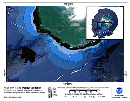
CRED Cumulative Map of Percent Scleractinian Coral Cover at Asuncion
Geospatial_Data_Presentation_Form: digital image
Online_Linkage: http://www.soest.hawaii.edu/pibhmc/pibhmc_cnmi_asu_optical.htm
Online_Linkage:
Description:
Abstract:
This map displays optical validation observation locations and percent coverage of scleractinian coral overlaid on bathymetry.
Purpose:
To display locations of optical validation data collected and percent coverage of scleractinian coral at Asuncion.
Supplemental_Information:
Ascuncion Island is an active volcanic cone and has a land area of 7.3 square km. The island is protected from development by the CNMI Constitution, as it has been declared a wildlife conservation area. It is home to nesting colonies of Sooty and Gray-backed Terns (Sterna fuscata and S. lunata, respectively). The seafloor off Ascuncion Island features high densities of sea pens in the vicinity of the 100 m isobath in some areas.
Cruises CoRIS Metadata Record Names
OES0307 cred_toad_asuncion_oes0307_2003
Resource Description: Digital video images that are geo-referenced to navigation files.
Time_Period_of_Content:
Time_Period_Information:
Range_of_Dates/Times:
Beginning_Date: 2003
Ending_Date: 2003
Currentness_Reference: ground condition
Status:
Progress: Complete
Maintenance_and_Update_Frequency: As needed
Spatial_Domain:
Bounding_Coordinates:
West_Bounding_Coordinate: 145.38
East_Bounding_Coordinate: 145.41
North_Bounding_Coordinate: 19.69
South_Bounding_Coordinate: 19.66
Keywords:
Theme:
Theme_Keyword_Thesaurus: NCEI Geoportal Filter
Theme_Keyword: CoRIS_Metadata
Theme:
Theme_Keyword_Thesaurus: CRCP Project
Theme_Keyword: Benthic Habitat Mapping and Characterization - CNMI and Guam
Theme_Keyword: 1398
Theme:
Theme_Keyword_Thesaurus: CoRIS Theme Thesaurus
Theme_Keyword: EARTH SCIENCE > Biosphere > Aquatic Habitat > Benthic Habitat
Theme_Keyword:
EARTH SCIENCE > Biosphere > Zoology > Corals > Reef monitoring and assessment > Mapping
Theme:
Theme_Keyword_Thesaurus: CoRIS Discovery Thesaurus
Theme_Keyword: Map Images > Habitats
Theme:
Theme_Keyword_Thesaurus: ISO 19115 Topic Category
Theme_Keyword: environment
Theme_Keyword: 007
Theme_Keyword: biota
Theme_Keyword: 002
Theme:
Theme_Keyword_Thesaurus: None
Theme_Keyword: Synthesis Map
Theme_Keyword: OES0307
Place:
Place_Keyword_Thesaurus: CoRIS Place Thesaurus
Place_Keyword:
COUNTRY/TERRITORY > Northern Mariana Islands > Asuncion Island > Asuncion Island (19N145E0001)
Place_Keyword:
OCEAN BASIN > Pacific Ocean > Western Pacific Ocean > Asuncion Island > Asuncion Island (19N145E0001)
Place:
Place_Keyword_Thesaurus: None
Place_Keyword: Commonwealth of Northern Marianas Islands and Guam
Place:
Place_Keyword_Thesaurus: CoRIS Region
Place_Keyword: CNMI
Access_Constraints: None
Use_Constraints:
Please acknowledge the NOAA Coral Reef Ecosystem Division, Pacific Islands Fisheries Science Center
as the source of this information.
Point_of_Contact:
Contact_Information:
Contact_Organization_Primary:
Contact_Organization:
Pacific Islands Benthic Habitat Mapping Center (PIBHMC), Coral Reef Ecosystem Division (CRED), Pacific Islands Fisheries Science Center (PIFSC), National Marine Fisheries Service (NMFS), National Oceanic and Atmospheric Administration (NOAA)
Contact_Address:
Address_Type: mailing and physical address
Address: NOAA IRC
Address: NMFS/PIFSC/CRED
Address: 1845 WASP Blvd., Building 176
City: Honolulu
State_or_Province: HI
Postal_Code: 96818
Contact_Voice_Telephone: 808 725-5360
Contact_Facsimile_Telephone: 808 725-5429
Contact_Electronic_Mail_Address: nmfs.pic.credinfo@noaa.gov
Contact_Instructions: e-mail preferred
Browse_Graphic:
Browse_Graphic_File_Name:
Browse_Graphic_File_Description:
This map displays optical validation observation locations and percent coverage of scleractinian coral overlaid on bathymetry.
Browse_Graphic_File_Type: JPEG
Data_Set_Credit:
Benthic Habitat Mapping Group, Coral Reef Ecosystem Division (CRED), Pacific Islands Fisheries Science
Center (PIFSC), NOAA
Security_Information:
Security_Classification_System: Not applicable
Security_Classification: Unclassified
Security_Handling_Description: Not applicable