Abstract:
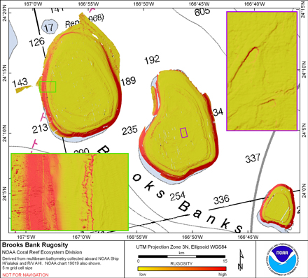
Rugosity is derived from gridded (5 m cell size)
multibeam bathymetry, collected aboard NOAA ship Hi'ialakai and R/V AHI using the
Benthic Terrain Modeler with rugosity methods by Jeff Jenness (2003).
Cell values reflect the (surface area) / (planimetric area)
ratio for the area contained within that cell's boundaries. They
provide indices of topographic roughness & convolutedness. This data
set is for Brooks Banks, Hawaii, USA.
Purpose:
The data were derived in support of NOAA Coral Reef Conservation
Program goals. Goal 1 is to map all U.S. Coral Reef Ecosystems.
This data set specifically addresses Objective 1 and 4: to develop
high-resolution benthic maps and to characterize priority deep
water reefs and associated habitats. This derivative of
bathymetry provides a GIS layer that may be used for benthic and
essential fish habitat characterization, and for the study of
geologic features. By combining the dataset with bathymetry,
backscatter, other derivatives, and in situ data, they
collectively compose benthic habitat maps which are designed to
be used to understand and predict moderate depth (~20m - 150m)
benthic habitats for different organisms that inhabit coral reef
ecosystems.
Supplemental_Information:
Multibeam data were collected aboard the NOAA Ship Hi'ialakai, a 218' United States
National Oceanographic and Atmospheric Administration research ship. The NOAA Ship
Hiialakai's survey sensors include a 30 kHz Simrad EM300 sonar and a 300 kHz Simrad
EM3002d sonar, which provide bathymetry and imagery data, a TSS/Applanix POS/MV
Model 320, which measures position,velocity, attitude and heading, and a Seabird
SBE 9/11 plus CTD used to measure sound velocity profiles.
Multibeam data were also collected aboard the R/V AHI (Acoustic Habitat Investigator),
a 25' survey launch owned and operated by the NOAA Pacific Islands Fisheries
Science Center in Honolulu, HI. The R/V AHI's survey sensors include a 240 kHz
RESON 8101-ER sonar providing bathymetry and imagery data, a TSS/Applanix
POS/MV Model 320 which measures position, velocity, attitude and heading, and
a Seabird SBE 19 CTD used to measure sound velocity profiles.
The metadata for the bathymetry is documented in the product metadata, Brooks_5m.asc.txt.
References:
Jenness, J. 2003. Grid surface areas: Surface area and ratios from
elevation grids [Electronic manual]. Jenness Enterprises:
ArcView Extensions.
http://www.jennessent.com/arcview/arcview_extensions.htm
Lundblad et al., 2006, A benthic terrain classification scheme for
American Samoa, Marine Geodesy, 29(2):89 - 111.
https://coast.noaa.gov/digitalcoast/tools/btm.html
Theme:
Theme_Keyword_Thesaurus: NCEI Geoportal Filter
Theme_Keyword: CoRIS_Metadata
Theme:
Theme_Keyword_Thesaurus: CRCP Project
Theme_Keyword:
M218 Benthic Habitat Mapping and Characterization in the Pacific Islands Region
Theme_Keyword: 1217
Theme:
Theme_Keyword_Thesaurus: ISO 19115 Topic Category
Theme_Keyword: imageryBaseMapsEarthCover
Theme_Keyword: 010
Theme:
Theme_Keyword_Thesaurus: CoRIS Theme Thesaurus
Theme_Keyword:
EARTH SCIENCE > Biosphere > Zoology > Corals > Reef Monitoring and Assessment > Mapping
Theme_Keyword:
EARTH SCIENCE > Biosphere > Zoology > Corals > Reef Monitoring and Assessment > Mapping > geomorphology Mapping
Theme_Keyword:
EARTH SCIENCE > Oceans > Bathymetry/Seafloor Topography > Rugosity
Theme:
Theme_Keyword_Thesaurus: CoRIS Discovery Thesaurus
Theme_Keyword: Geographic Information > Habitats
Place:
Place_Keyword_Thesaurus: CoRIS Place Thesaurus
Place_Keyword:
COUNTRY/TERRITORY > United States of America > Hawaii > Honolulu > Brooks Banks (24N166W0002)
Place_Keyword:
OCEAN BASIN > Pacific Ocean > Central Pacific Ocean > Northwestern Hawaiian Islands > Brooks Banks (24N166W0002)
Place:
Place_Keyword_Thesaurus: CoRIS Region
Place_Keyword: NWHI
These data are not to be used for navigation
purposes. Please acknowledge the NOAA Pacific Islands Fisheries
Science Center (PIFSC) Coral Reef Ecosystem Division (CRED) and
the Pacific Islands Benthic Habitat Mapping Center, and the
Joint Institute for Marine and Atmospheric Research (JIMAR) and
School of Ocean and Earth Science and Technology (SOEST),
University of Hawaii as the sources of this information.
NOAA PIFSC CRED and the Pacific Islands Benthic Habitat
Mapping Center, JIMAR and SOEST