Multibeam data were collected aboard the NOAA Ship Hi'ialakai, a 218' United States National Oceanographic and Atmospheric Administration research ship. The NOAA Ship Hi'ialakai's survey sensors include a 30 kHz Simrad EM300 sonar and a 300 kHz Simrad EM3002d sonar, which provide bathymetry and imagery data, a TSS/Applanix POS/MV Model 320, which measures position, velocity, attitude and heading, and a Seabird SBE 9/11 plus CTD used to measure sound velocity profiles.
Multibeam data were also collected aboard the R/V AHI (Acoustic Habitat Investigator), a 25' survey launch owned and operated by the NOAA Pacific Islands Fisheries Science Center in Honolulu, HI. The R/V AHI's survey sensors include a 240 kHz RESON 8101-ER sonar providing bathymetry and imagery data, a TSS/Applanix POS/MV Model 320 which measures position, velocity, attitude and heading, and a Seabird SBE 19 CTD used to measure sound velocity profiles.
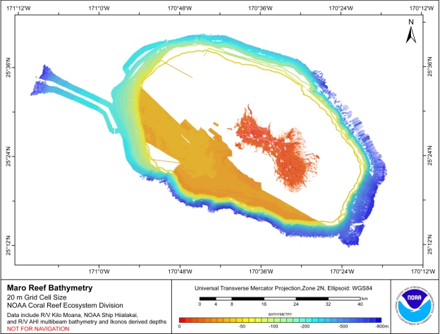
IKONOS estimated depths were produced using rule-based, semi-automated image analysis of high-resolution satellite imagery for nine locations in the Northwestern Hawaiian Islands.For more information about the estimated depth data see the following online link: http://mercury.ornl.gov/metadata/nbii/html/nos/est%5Fdepth%5Fnwhi.html
Specific equipment configurations are documented in metadata from IKONOS Estimated Depths and cruises KMO206, HI0503, HI0507, HI0508. These metadata can be accessed at: https://www.soest.hawaii.edu/pibhmc/cms/cruise-catalog/