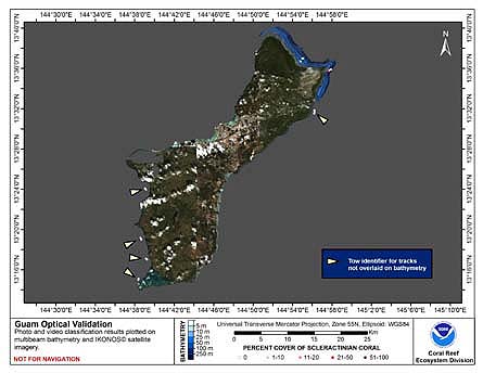
This map displays optical validation observation locations and percent coverage of scleractinian coral overlaid on bathymetry.
To display locations of optical validation data collected and percent coverage of scleractinian coral at Guam.
Guam, a U.S. territory located at 13.28 degrees North, 144.45 degrees East, is the southernmost island in the Mariana Archipelago. It is
the largest island in Micronesia, with a land mass of 560 square km and a maximum elevation of approximately 405 m.
It is also the most heavily populated island in Micronesia, with a population of about 164,000. The northern portion
of the island is relatively flat and consists primarily of uplifted limestone. The southern half of the island is
primarily volcanic, with more topographic relief and large areas of highly erodible lateritic soils. Those conditions
have led to the creation of a number of watersheds throughout the southern areas which are drained by 96 rivers.
The island possesses fringing reefs, patch reefs, submerged reefs, offshore banks, and barrier reefs surrounding
Cocos Lagoon in the south and part of Apra Harbor. Guam's coral reefs are an important component of the island's tourism industry and make Guam a popular tourist destination for Asian travelers. Traditionally, coral reef fishery resources formed a substantial part of the local Chamorro community's diet and included finfish, invertebrates, and sea turtles. Today coral reef
resources are both economically and culturally important, although somewhat displaced from the diet by westernization
and declining stocks. Over 10 percent of Guam's coastline has been set aside in five marine preserves, established in
1997 as a response to decreasing reef fish stocks. While management practices are enforced in the marine preserves,
there is currently limited management and enforcement in the other areas. The health of Guam's coral reefs varies
considerably, depending on a variety of factors including geology, human population density, level of coastal
development, level and types of uses of marine resources, oceanic circulation patterns, and frequency of natural
disturbances, such as typhoons and earthquakes. Many of Guam's reefs have declined in health over the past 40 years,
with the average live coral cover on forereef slopes dwindling from approximately 50 percent in the 1960s to less than
25 percent by the 1990s.
Cruises CoRIS Metadata Record Names
OES0308 cred_toad_guam_2003
Resource Description: Digital video images that are geo-referenced to navigation files.