Citation:
Citation_Information:
Originator:
Pacific Islands Benthic Habitat Mapping Center (PIBHMC), Coral Reef Ecosystem Division (CRED), Pacific Islands Fisheries Science Center (PIFSC), National Marine Fisheries Service (NMFS), National Oceanic and Atmospheric Administration (NOAA)
Publication_Date: 200705
Title:
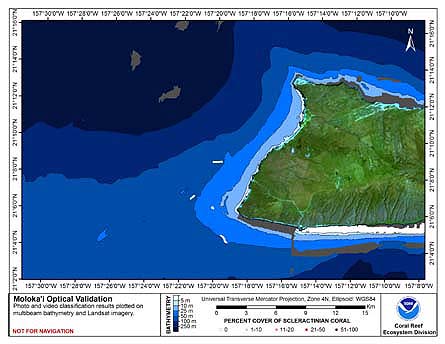
CRED Cumulative Map of Percent Scleractinian Coral Cover at Molokai, 2005
Geospatial_Data_Presentation_Form: digital image
Online_Linkage: http://www.soest.hawaii.edu/pibhmc/pibhmc_mhi_mol_optical.htm
Online_Linkage:
Description:
Abstract:
This map displays optical validation observation locations and percent coverage of scleractinian coral
overlaid on bathymetry.
Purpose:
To display locations of optical validation data collected and percent coverage of scleractinian coral at
Molokai.
Supplemental_Information:
Molokai, formed from two extinct volcanoes, covers an area of 673 sq. km and reaches 1515 m
at its highest point. Generally situated between Maui and Oahu at 21 degrees 08'N, 157 degrees 00' W, the island
has 142 km of shoreline and an estimated 998 sq. km of reef (Hawaii Coral Reef Network). The island is one the four
members of the Maui Group (also including Maui, Lanai and Kahoolawe), situated together on a shallow, submerged bank.
In the recent geological past, the islands formed a single land mass (Maui Nui) during periods of lowered sea levels.
Like all of the main Hawaiian islands, it is considered a high island and contributes significant nutrient and
sediment runoff to coastal waters. Molokai's human population was counted at 6,717 in 1990, mostly scattered around
the island. There are no designated marine protected areas around Molokai, although the Hawaiian Islands Humpback
Whale National Marine Sanctuary spans 3642 sq. km of the waters among and around the Maui Group. Penguin Bank is a
flat-topped feature with a surface area of 1015 sq. km that extends from the west coast of Molokai approximately
70 km to the southwest.
Cruises CoRIS Metadata Record Names
HI0504 cred_toad_molokai_2005
Resource Description: Digital video images that are geo-referenced to navigation files.
Time_Period_of_Content:
Time_Period_Information:
Range_of_Dates/Times:
Beginning_Date: 2005
Ending_Date: 2005
Currentness_Reference: ground condition
Status:
Progress: Complete
Maintenance_and_Update_Frequency: As needed
Spatial_Domain:
Bounding_Coordinates:
West_Bounding_Coordinate: -157.51321
East_Bounding_Coordinate: -157.28333
North_Bounding_Coordinate: 21.15034
South_Bounding_Coordinate: 20.91766
Keywords:
Theme:
Theme_Keyword_Thesaurus: NCEI Geoportal Filter
Theme_Keyword: CoRIS_Metadata
Theme:
Theme_Keyword_Thesaurus: CRCP Project
Theme_Keyword:
Benthic Habitat Mapping and Characterization - Northwestern and Main Hawaiian Islands
Theme_Keyword: 1217
Theme:
Theme_Keyword_Thesaurus: CoRIS Theme Thesaurus
Theme_Keyword: EARTH SCIENCE > Biosphere > Aquatic Habitat > Benthic Habitat
Theme_Keyword:
EARTH SCIENCE > Biosphere > Zoology > Corals > Reef Monitoring and Assessment > Mapping
Theme_Keyword:
EARTH SCIENCE > Oceans > Coastal Processes > Coral Reefs > Coral Reef Ecology > Coral Cover
Theme_Keyword: EARTH SCIENCE > Oceans > Coastal Processes > Coral Reefs
Theme:
Theme_Keyword_Thesaurus: CoRIS Discovery Thesaurus
Theme_Keyword: Map Images > Habitats
Theme:
Theme_Keyword_Thesaurus: ISO 19115 Topic Category
Theme_Keyword: environment
Theme_Keyword: 007
Theme_Keyword: biota
Theme_Keyword: 002
Theme:
Theme_Keyword_Thesaurus: None
Theme_Keyword: Synthesis Map
Theme_Keyword: HI0504
Theme_Keyword: Tethered Optical Validation Data
Place:
Place_Keyword_Thesaurus: CoRIS Place Thesaurus
Place_Keyword:
OCEAN BASIN > Pacific Ocean > Central Pacific Ocean > Hawaiian Islands > Molokai Island > Molokai Island (21N157W0001)
Place_Keyword:
COUNTRY/TERRITORY > United States of America > Hawaii > Hawaii > Molokai Island (21N157W0001)
Place:
Place_Keyword_Thesaurus: CoRIS Region
Place_Keyword: MHI
Access_Constraints: None
Use_Constraints:
Please acknowledge the NOAA Coral Reef Ecosystem Division, Pacific Islands Fisheries Science Center
as the source of this information.
Point_of_Contact:
Contact_Information:
Contact_Organization_Primary:
Contact_Organization:
Pacific Islands Benthic Habitat Mapping Center (PIBHMC), Coral Reef Ecosystem Division (CRED), Pacific Islands Fisheries Science Center (PIFSC), National Marine Fisheries Service (NMFS), National Oceanic and Atmospheric Administration (NOAA)
Contact_Person: John Rooney
Contact_Address:
Address_Type: mailing and physical address
Address: NOAA IRC
Address: NMFS/PIFSC/CRED
Address: 1845 WASP Blvd., Building 176
City: Honolulu
State_or_Province: HI
Postal_Code: 96818
Contact_Voice_Telephone: 808 725-5360
Contact_Facsimile_Telephone: 808 725-5429
Contact_Electronic_Mail_Address: nmfs.pic.credinfo@noaa.gov
Contact_Instructions: e-mail preferred
Browse_Graphic:
Browse_Graphic_File_Name:
Browse_Graphic_File_Description:
This map displays optical validation observation locations and percent coverage of scleractinian coral
overlaid on bathymetry.
Browse_Graphic_File_Type: JPEG
Data_Set_Credit:
Benthic Habitat Mapping Group, Coral Reef Ecosystem Division (CRED), Pacific Islands Fisheries Science
Center (PIFSC), NOAA
Security_Information:
Security_Classification_System: Not applicable
Security_Classification: Unclassified
Security_Handling_Description: Not applicable