CRED Optical Validation Data at Midway Island, 2002, to Support Benthic Habitat Mapping

Metadata also available as [Questions & Answers] - [Parseable text] - [XML]

Metadata:


Identification_Information:
Citation:
Citation_Information:
Originator:
Pacific Islands Benthic Habitat Mapping Center (PIBHMC), Coral Reef Ecosystem Division (CRED), Pacific Islands Fisheries Science Center (PIFSC), National Marine Fisheries Service (NMFS), National Oceanic and Atmospheric Administration (NOAA)
Publication_Date: 200606
Title:
CRED Optical Validation Data at Midway Island, 2002, to Support Benthic Habitat Mapping
Geospatial_Data_Presentation_Form:
Video and photo imagery, track line navigation files, and log sheets
Online_Linkage: http://www.soest.hawaii.edu/pibhmc/
Description:
Abstract:
Optical validation data were collected using a Tethered Optical Assessment Device (TOAD), an underwater sled equipped with an underwater digital video camera and lights. Data were collected at the Northwestern Hawaiian Islands, Midway Island to support Benthic Habitat Mapping efforts.
Purpose:
This data provides optical observations that will be correlated with bathymetry and acoustic backscatter imagery to develop a benthic habitat map of Midway Island. Refer to supplemental information for description of instrument and survey.
Supplemental_Information:
The Midway Islands, located at 28.2 N, 177.4W and 1.42 sq. km in area, are enclosed in the classically shaped Midway Atoll. The underlying basalt, covered by more than 400m of fossil reef, is estimated to be 28 million years old. (Boreholes drilled by Ladd et al. [reported in Science in 1967] reached basalt 152m below Sand Island.) Within the reef are two islands; Sand Island was extensively modified starting in 1856 when reefs were blasted to create a port. Midway was an important stopover on transpacific voyages, and saw regular commercial ship and seaplane traffic. During the U.S. Navy's occupation of the atoll beginning in the 1940s, Sand Island and Eastern Island were extensively modified to create airstrips and widen the southern shipping channel. The atoll and banks include 223 sq. km area with of depths less than 100 m. The area is now the Midway Atoll National Wildlife Refuge which is under jurisdiction of the U.S. Fish and Wildlife Service.

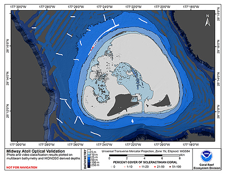
Optical validation data were collected using the Tethered Optical Assessment Device (TOAD), a sled equipped with underwater video camera, still camera, and lights. These data are used to provide ground-truth validation that for benthic habitat maps based on multibeam echosounder surveys. Camera sled deployments were conducted at night, usually between 1800 and midnight. The TOAD was deployed from a pot hauler mounted on the starboard side of the fantail on NOAA Ship Townsend Cromwell. It was lowered slowly to the bottom by the deck crew with the use of a capstan. The TOAD operator monitored a live video feed from the camera and began recording data on two video tape recorders. When the camera reached bottom the deck crew was notified by radio to stop lowering. The TOAD was a MiniBat 8820 unit manufactured by Guideline, and was towed by the ship at 1-2 knots while remotely guided from the ship using adjustable wing controls to keep the unit close to the underwater substrate. The TOAD was damaged during the cruise on 02/20/02, and subsequent tows were conducted as drift deployments. At each station the ship was positioned with the wind on the starboard side and drifted downwind; occasional light turns were applied to the ship's screws if necessary to reduce the ship's motion. The operator continued to monitor the vehicle and provided commands to raise or lower it to keep the camera just above the bottom.

Equipment Description: The TOAD is a camera sled based on the Guildline MiniBat model 8820 tow body. The frame was configured with a single Sony DCR-PC110 Digital Video Camera in a modified Gates underwater housing, a Canon Power Shot G1 Still Camera (modified by CRED engineers) in an Ikelite housing rated to 60 m slaved to an Ikelite DS-50 strobe, and two 500 W DeepSea Power & Light model 710-0400601 underwater lights. The Canon camera had a custom-built timer that enabled the user to select a constant time interval (ranging from approximately 5 seconds to 2 minutes) between photographs. An interval of 30 seconds was typically selected, which, assuming a mean velocity for the camera sled of 1.5 knots, resulted in one photograph approximately every 20 m. Photograph resolution is 2048 x 1536 pixels and file names are assigned sequentially and automatically by the camera, starting at 100-0000 after the camera's memory is cleared. The MiniBat pressure sensor and wing controller were also mounted on the frame but the pressure sensor was not operational. After damage to the TOAD on 02/20/02 and the sled's wings were not installed thereafter. The cable between the sled and the surface was an underwater load-bearing electrical cable. The TOAD computers were located in the Electronics Lab of the Townsend Cromwell. The electronics box containing the power switches was secured to the ship's fantail, and all other TOAD surface components were secured in the ship's wet lab.

Name & address of person collecting data: Joyce Miller & Ronald Hoeke NOAA IRC NMFS/PIFSC/CRED 1845 WASP Blvd., Building 176 Honolulu, HI 96818

Data Files: Video data were recorded on two video tape recorders. Still photos were recorded on digital camera and downloaded to the TOAD computer after the tow. The position of the camera sled was recorded using Guildline MiniBat In-Tow data acquisition software.

File naming convention: Each tow is given a name consisting of a 3-letter designator for the island area, "MID" in this case followed by a five-digit tow number. The first two digits indicate the last two digits of the calendar year, i.e., "02" is used for this cruise, which took place in 2002. The last three numbers indicate the consecutive number of the tow for that island and year, and start on the next hundred for subsequent cruises in that year to the same island. During TC0207 the consecutive numbers started at 004. Video tape labels, the navigation files (*.glo) and paper log forms are all annotated with the tow name. Metadata were extracted from the navigation data and recorded to a file with the same name as the navigation file except that a file type of ".met" was appended; for example, "MID02004.glo.met"

Time Correlation: All times are based on UTC. Two clocks were set manually synchronized prior to starting data collection; the clock in the video character generator that was used to annotate the video tape and the TOAD data acquisition computer clock was used to annotate the navigation (*.glo) files. These clocks were set to UTC at the beginning of each evening's operations and then compared to one another prior to (and during) each tow. There were problems maintaining synchronization of the TOAD computer clock during this cruise. See the problems section for a description.

Resource Description: Digital video images that are geo-referenced to navigation files.

Time_Period_of_Content:
Time_Period_Information:
Range_of_Dates/Times:
Beginning_Date: 20020922
Ending_Date: 20020926
Currentness_Reference: ground condition
Status:
Progress: Complete
Maintenance_and_Update_Frequency: As needed
Spatial_Domain:
Bounding_Coordinates:
West_Bounding_Coordinate: -177.41977
East_Bounding_Coordinate: -177.38267
North_Bounding_Coordinate: 28.28858
South_Bounding_Coordinate: 28.25578
Keywords:
Theme:
Theme_Keyword_Thesaurus: NCEI Geoportal Filter
Theme_Keyword: CoRIS_Metadata
Theme:
Theme_Keyword_Thesaurus: CRCP Project
Theme_Keyword:
Benthic Habitat Mapping and Characterization - Northwestern and Main Hawaiian Islands
Theme_Keyword: 1217
Theme:
Theme_Keyword_Thesaurus: CoRIS Theme Thesaurus
Theme_Keyword: EARTH SCIENCE > Biosphere > Aquatic Habitat > Benthic Habitat
Theme_Keyword:
EARTH SCIENCE > Biosphere > Zoology > Corals > Reef Monitoring and Assessment > Mapping
Theme_Keyword:
EARTH SCIENCE > Biosphere > Zoology > Corals > Reef Monitoring and Assessment > Photographic Analysis > Videography
Theme:
Theme_Keyword_Thesaurus: None
Theme_Keyword: Tethered Optical Assessment Device (TOAD)
Theme_Keyword: Underwater video
Theme_Keyword: TC0207
Theme:
Theme_Keyword_Thesaurus: CoRIS Discovery Thesaurus
Theme_Keyword: Visual Images > Habitats
Theme:
Theme_Keyword_Thesaurus: ISO 19115 Topic Category
Theme_Keyword: environment
Theme_Keyword: 007
Theme_Keyword: biota
Theme_Keyword: 002
Place:
Place_Keyword_Thesaurus: CoRIS Place Thesaurus
Place_Keyword:
OCEAN BASIN > Pacific Ocean > Central Pacific Ocean > Northwestern Hawaiian Islands > Midway Atoll (28N177W0001)
Place_Keyword:
COUNTRY/TERRITORY > United States of America > Hawaii > Honolulu > Midway Atoll (28N177W0001)
Place_Keyword:
OCEAN BASIN > Pacific Ocean > Central Pacific Ocean > Northwestern Hawaiian Islands (28N178W0000)
Place_Keyword:
COUNTRY/TERRITORY > United States of America > Hawaii > Honolulu > Northwestern Hawaiian Islands (28N178W0000)
Place:
Place_Keyword_Thesaurus: CoRIS Region
Place_Keyword: NWHI
Access_Constraints: None
Use_Constraints:
Please acknowledge the NOAA Coral Reef Ecosystem Division, Pacific Islands Fisheries Science Center as the source of this information.
Point_of_Contact:
Contact_Information:
Contact_Organization_Primary:
Contact_Organization:
Pacific Islands Benthic Habitat Mapping Center (PIBHMC), Coral Reef Ecosystem Division (CRED), Pacific Islands Fisheries Science Center (PIFSC), National Marine Fisheries Service (NMFS), National Oceanic and Atmospheric Administration (NOAA)
Contact_Address:
Address_Type: mailing and physical address
Address: NOAA IRC
Address: NMFS/PIFSC/CRED
Address: 1845 WASP Blvd., Building 176
City: Honolulu
State_or_Province: HI
Postal_Code: 96818
Contact_Voice_Telephone: 808 725-5360
Contact_Facsimile_Telephone: 808 725-5429
Contact_Electronic_Mail_Address: nmfs.pic.credinfo@noaa.gov
Contact_Instructions: e-mail preferred
Browse_Graphic:
Browse_Graphic_File_Name:
http://www.soest.hawaii.edu/pibhmc/NWHI_images/mid_toad_445px.jpg
Browse_Graphic_File_Description: Midway Atoll, NWHI: TOAD Tows and Multibeam Bathymetry
Browse_Graphic_File_Type: JPEG
Data_Set_Credit:
Benthic Habitat Mapping Group, Coral Reef Ecosystem Division (CRED), Pacific Islands Fisheries Science Center (PIFSC), NOAA
Security_Information:
Security_Classification_System: Not applicable
Security_Classification: Unclassified
Security_Handling_Description: Not applicable

Data_Quality_Information:
Logical_Consistency_Report: Unspecified
Completeness_Report: Complete
Positional_Accuracy:
Horizontal_Positional_Accuracy:
Horizontal_Positional_Accuracy_Report:
The horizontal position accuracy for the camera sled position is 100 meters. There are three primary sources of this error. The ship's positioning is based on GPS SPS, often called standalone or non-differential GPS positioning. SPS has a measured accuracy of under 5 meters. The position of the GPS antenna is used; no attempt is made to translocate this position to that of the tow block from which the camera is deployed. The difference between the tow block and the antenna is about 14 meters. The camera sled position is based a layback calculation that use ship's course, the amount of cable out and the camera sled depth to develop an estimate of the camera sled position. The amount of cable deployed is manually entered by the operator during a given camera tow.
Lineage:
Process_Step:
Process_Description:
After a tow was completed the video tape data was reviewed by spot-checking the master and backup tape to verify that data were recorded. Navigation data were copied from the acquisition computer to the data archive. A metadata extractor (gloFilter.py, version 3/06) was run to summarize the navigation data and test for errors. If errors were detected they were corrected or flagged as appropriate and a new data file was made. This file's header was updated to document what type of processing occurred. A metadata file was recorded in the data archive in the same location as the navigation data. Processed navigation data were then read into ArcView 3.2 shapefiles using an ArcView Avenue script named "TOAD.Import.Playback", version 9/25/01, written by Ronald Hoeke.
Process_Date: 20041015

Spatial_Reference_Information:
Horizontal_Coordinate_System_Definition:
Geographic:
Latitude_Resolution: 0.0001
Longitude_Resolution: 0.0001
Geographic_Coordinate_Units: Decimal Degrees
Geodetic_Model:
Horizontal_Datum_Name: D_WGS_1984
Ellipsoid_Name: WGS_1984
Semi-major_Axis: 6378137.000000
Denominator_of_Flattening_Ratio: 298.257224
Vertical_Coordinate_System_Definition:
Depth_System_Definition:
Depth_Datum_Name: No correction
Depth_Resolution: 0.1
Depth_Distance_Units: meters
Depth_Encoding_Method: Attribute Values

Distribution_Information:
Distributor:
Contact_Information:
Contact_Organization_Primary:
Contact_Organization:
Pacific Islands Benthic Habitat Mapping Center (PIBHMC), Coral Reef Ecosystem Division (CRED), Pacific Islands Fisheries Science Center (PIFSC), National Marine Fisheries Service (NMFS), National Oceanic and Atmospheric Administration (NOAA)
Contact_Address:
Address_Type: mailing and physical address
Address: NOAA IRC
Address: NMFS/PIFSC/CRED
Address: 1845 WASP Blvd., Building 176
City: Honolulu
State_or_Province: HI
Postal_Code: 96818
Contact_Voice_Telephone: 808 725-5360
Contact_Facsimile_Telephone: 808 725-5429
Contact_Electronic_Mail_Address: nmfs.pic.credinfo@noaa.gov
Contact_Instructions: e-mail preferred
Resource_Description: Offline Data
Distribution_Liability:
These data are not to be used for navigational purposes. NOAA makes no warranty regarding these data, expressed or implied, nor does the fact of distribution constitute such a warranty. NOAA cannot assume liability for any damages caused by any errors or omissions in these data, nor as a result of the failure of these data to function on a particular system.
Standard_Order_Process:
Digital_Form:
Digital_Transfer_Information:
Format_Name: ASCII
Format_Information_Content:
Each comma-delimited record contains year, day of year, time, latitude, longitude, velocity north and east, water column depth, vehicle depth, layback, and wing angle. For this data set the fields for vehicle depth and wing angle do not contain useful data. List of navigation files: MID02004.glo MID02010.glo
Digital_Transfer_Option:
Offline_Option:
Offline_Media: CD-ROM
Recording_Format: ISO 9660
Digital_Form:
Digital_Transfer_Information:
Format_Name: mini digital video
Format_Information_Content:
List of video tapes: MID02004, VHS, Master MID02004, Mini DV, Master MID02004, Mini DV, Backup
Digital_Transfer_Option:
Offline_Option:
Offline_Media: Video cassette tape
Recording_Format: Mini DV
Digital_Form:
Digital_Transfer_Information:
Format_Name: JPG digital still photo
Format_Information_Content:
58 still images available; poor photos were enhanced or deleted List of photo folders: MID02010: MID_092602_0537 (58 photos)
Digital_Transfer_Option:
Offline_Option:
Offline_Media: CD-ROM
Recording_Format: JPEG
Fees: None

Metadata_Reference_Information:
Metadata_Date: 20200329
Metadata_Review_Date: 20110323
Metadata_Contact:
Contact_Information:
Contact_Organization_Primary:
Contact_Organization:
Pacific Islands Benthic Habitat Mapping Center (PIBHMC), Coral Reef Ecosystem Division (CRED), Pacific Islands Fisheries Science Center (PIFSC), National Marine Fisheries Service (NMFS), National Oceanic and Atmospheric Administration (NOAA)
Contact_Address:
Address_Type: mailing and physical address
Address: NOAA IRC
Address: NMFS/PIFSC/CRED
Address: 1845 WASP Blvd., Building 176
City: Honolulu
State_or_Province: HI
Postal_Code: 96818
Contact_Voice_Telephone: 808 725-5360
Contact_Facsimile_Telephone: 808 725-5429
Contact_Electronic_Mail_Address: nmfs.pic.credinfo@noaa.gov
Contact_Instructions: e-mail preferred
Metadata_Standard_Name: FGDC Content Standard for Digital Geospatial Metadata
Metadata_Standard_Version: FGDC-STD-001-1998

CoRIS:
CoRIS_ID: 20080502030113
CoRIS_Children: None
CoRIS_Beginning_Date: 20020922
CoRIS_Ending_Date: 20020926
CoRIS_Metadata_Link:
https://www.coris.noaa.gov/metadata/records/html/cred_toad_midway_tc0207_2002.html
CoRIS_Tracking_ID: 1485

Generated by mp version 2.9.48 on Wed Mar 27 10:52:19 2024