Citation_Information:
Originator:
Pacific Islands Benthic Habitat Mapping Center (PIBHMC), Coral Reef Ecosystem Division (CRED), Pacific Islands Fisheries Science Center (PIFSC), National Marine Fisheries Service (NMFS), National Oceanic and Atmospheric Administration (NOAA)
Publication_Date: 20121130
Title:
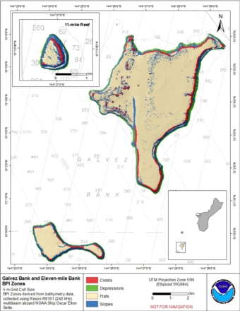
Bathymetric Position Index (BPI) Zones 5 m grid derived from gridded bathymetry of of Galvez Bank, South Galvez Bank, and 11-Mile Reef, Territory of Guam, USA.
Geospatial_Data_Presentation_Form: raster digital data
Online_Linkage:
Online_Linkage: http://www.soest.hawaii.edu/pibhmc
Abstract:
BPI Zones are derived from a focal mean
analysis on bathymetry and slope. The grid is based on
gridded (5 m cell size) multibeam bathymetry, collected aboard NOAA Ship Oscar Elton Sette.
BPI Zones was created using the Benthic
Terrain Modeler (
https://coast.noaa.gov/digitalcoast//tools/btm/). Cell values
represent one of 4 classes (crest, depression, slope, flat) in an index of seafloor terrains.
The data were derived in support of Coral Reef Conservation
Program goals. Goal 1 is to map all U.S. Coral Reef Ecosystems.
This data set specifically addresses Objective 1 and 4: to develop
high-resolution benthic maps and to characterize priority deep
water reefs and associated habitats. This derivative of
bathymetry provides a GIS layer that may be used for benthic and
essential fish habitat characterization, and for the study of
geologic features. By combining the dataset with bathymetry,
backscatter, other derivatives, and in situ data, they
collectively compose benthic habitat maps which are designed to
be used to understand and predict moderate depth (~20m to ~150m)
benthic habitats for different organisms that inhabit coral
reef ecosystems.
Supplemental_Information:
Gridded bathymetry data were collected aboard the NOAA Ship Oscar Elton Sette, a 224' (68 m) United States
National Oceanographic and Atmospheric Administration research ship. The NOAA Ship
Sette's survey sensors included a 240-kHz pole-mounted Reson 8101ER sonar, which provides
bathymetry and imagery data, a TSS/Applanix POS/MV Model 320, which measures position,velocity, attitude and
heading, and a Seabird SBE19 CTD used to measure sound velocity profiles.
The metadata for the bathymetry is documented in this product metadata:
ftp://ftp.soest.hawaii.edu/pibhmc/website/data/cnmi-guam/bathymetry/3Banks_Guam_5m.txt
Specific equipment configurations are documented in metadata from cruise
SE1002. These metadata can be accessed at:
https://www.soest.hawaii.edu/pibhmc/cms/cruise-catalog/
References:
Lundblad et al., 2006, A benthic terrain classification scheme for
American Samoa, Marine Geodesy, 29(2):89 - 111.
https://coast.noaa.gov/digitalcoast/tools/btm.html
Spatial_Data_Organization_Information
Direct_Spatial_Reference_Method Raster
Raster_Object_Information gal_bpiz
Raster_Object_Type Grid Cell
Row_Count 1869
Column_Count 1623
Vertical_Count 1
Spatial_Data_Organization_Information
Direct_Spatial_Reference_Method Raster
Raster_Object_Information sgal_bpiz
Raster_Object_Type Grid Cell
Row_Count 905
Column_Count 1293
Vertical_Count 1
Spatial_Data_Organization_Information
Direct_Spatial_Reference_Method Raster
Raster_Object_Information ele_bpiz
Raster_Object_Type Grid Cell
Row_Count 357
Column_Count 307
Vertical_Count 1
Theme:
Theme_Keyword_Thesaurus: NCEI Geoportal Filter
Theme_Keyword: CoRIS_Metadata
Theme:
Theme_Keyword_Thesaurus: CRCP Project
Theme_Keyword:
Benthic Habitat Mapping and Characterization in the Pacific Islands Region
Theme_Keyword: 467
Theme:
Theme_Keyword_Thesaurus: CoRIS Theme Thesaurus
Theme_Keyword:
EARTH SCIENCE > Biosphere > Zoology > Corals > Reef Monitoring and Assessment > Mapping > geomorphology Mapping
Theme_Keyword:
EARTH SCIENCE > Biosphere > Aquatic Habitat > Reef Habitat > Description
Theme_Keyword:
EARTH SCIENCE > Oceans > Bathymetry/Seafloor Topography > Bathymetry
Theme_Keyword:
EARTH SCIENCE > Oceans > Bathymetry/Seafloor Topography > Bathymetric Position Index Zones
Theme:
Theme_Keyword_Thesaurus: ISO 19115 Topic Category
Theme_Keyword: imageryBaseMapsEarthCover
Theme_Keyword: 010
Theme:
Theme_Keyword_Thesaurus: CoRIS Discovery Thesaurus
Theme_Keyword: Geographic Information > Habitats
Place:
Place_Keyword_Thesaurus: None
Place_Keyword: Galvez Bank
Place_Keyword: Territory of Guam
Place_Keyword: United States of America
Place:
Place_Keyword_Thesaurus: None
Place_Keyword: South Galvez Bank
Place_Keyword: Territory of Guam
Place_Keyword: United States of America
Place:
Place_Keyword_Thesaurus: None
Place_Keyword: 11-Mile Reef
Place_Keyword: Territory of Guam
Place_Keyword: United States of America
Place:
Place_Keyword_Thesaurus: CoRIS Place Thesaurus
Place_Keyword:
COUNTRY/TERRITORY > United States of America > Guam > Galvez Bank (13N144E0049)
Place_Keyword:
COUNTRY/TERRITORY > United States of America > Guam > Guam (13N144E0000)
Place_Keyword:
OCEAN BASIN > Pacific Ocean > Western Pacific Ocean > Guam > Guam (13N144E0000)
Place_Keyword:
OCEAN BASIN > Pacific Ocean > Western Pacific Ocean > Guam > Galvez Bank (13N144E0049)
Place:
Place_Keyword_Thesaurus: CoRIS Region
Place_Keyword: Guam
These data are not to be used for navigation purposes. Please acknowledge the NOAA Pacific Islands Fisheries
Science Center (PIFSC) Coral Reef Ecosystem Division (CRED) and
the Pacific Islands Benthic Habitat Mapping Center, and the Joint
Institute for Marine and Atmospheric Research (JIMAR) and School
of Ocean and Earth Science and Technology (SOEST), University of
Hawaii as the sources of this information.
ArcGIS ASCII file, derived from bathymetry and
slope in ArcGIS 10.1 (Benthic Terrain Modeler)