Citation:
Citation_Information:
Originator:
Pacific Islands Benthic Habitat Mapping Center (PIBHMC), Coral Reef Ecosystem Division (CRED), Pacific Islands Fisheries Science Center (PIFSC), National Marine Fisheries Service (NMFS), National Oceanic and Atmospheric Administration (NOAA)
Publication_Date: 20110304
Title:
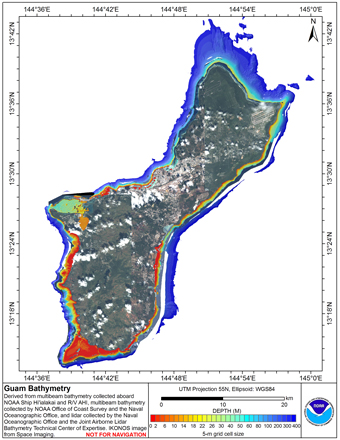
Mosaic of gridded multibeam and lidar bathymetry of the US Territory of Guam
Online_Linkage: http://www.soest.hawaii.edu/pibhmc
Online_Linkage:
Description:
Abstract:
Gridded multibeam bathymetry is integrated with gridded lidar bathymetry.
Gridded (5 m cell size) multibeam bathymetry were collected aboard NOAA Ship
Hiialaka'i and R/V AHI and by the Naval Oceanographic Office and NOAA
Office of Coast Survey in Apra Harbor. Lidar bathymetry were collected by the Naval
Oceanographic Office and by the Joint Airborne Lidar Bathymetry Technical Center
of Expertise. This dataset is for the shelf environment of the US Territory of Guam Island
Purpose:
The data were derived in support of NOAA Coral Reef Conservation
Program goals. Goal 1 is to map all U.S. Coral Reef Ecosystems.
This data set specifically addresses Objective 1 and 4: to develop
high-resolution benthic maps and to characterize priority deep
water reefs and associated habitats. This integration of derived
bathymetry with multibeam sonar data provides a GIS layer with
expanded spatial coverage that may be used for benthic and essential
fish habitat characterization, and for the study of geologic features.
By combining the dataset with other bathymetry, backscatter, derivatives,
and in situ data, they collectively compose benthic habitat maps
designed to be used to understand and predict shallow depth (0m to 150m)
benthic habitats for organisms that inhabit coral reef ecosystems.
Supplemental_Information:
Gridded multibeam data were collected by CRED in 2003 and 20007 aboard the Hi'ialakai, a 218'
United States National Oceanographic and Atmospheric Administration
(NOAA) research ship, and aboard the R/V AHI (Acoustic Habitat
Investigator), a 25' survey launch owned and operated by the NOAA
Pacific Islands Fisheries Science Center in Honolulu, HI. The
metadata for these bathymetry is documented in the product metadata,
guam_5m.txt on
ftp://ftp.soest.hawaii.edu/pibhmc/website/data/cnmi-guam/bathymetry
Multibeam data were also collected by the Naval Oceanographic Office and NOAA
Office of Coast Survey in 2008, in Apra Harbor. These data are also presented
in a 1-m resolution grid online, and metadata for these data are documented in the
product metadata apra_bty_1m.txt on
http://www.soest.hawaii.edu/pibhmc/pibhmc_cnmi_apra_bathy.htm.
Lidar data were provided by the Naval Oceanographic Office, and were obtained
using a SHOALS airborne system during January-March 2001. Additional lidar data were
collected by the Joint Airborne Lidar Bathymetry Technical Center of Expertise (JALBTCX).
These data were collected using the CHARTS system between February 18 and May 20 2007.
These data are available on NGDC and more detailed metadata for these data can be found on
https://coast.noaa.gov/digitalcoast//data/index.html
Time_Period_of_Content:
Time_Period_Information:
Range_of_Dates/Times:
Beginning_Date: 20010301
Ending_Date: 20080504
Currentness_Reference: ground condition
Status:
Progress: Complete
Maintenance_and_Update_Frequency: As needed
Spatial_Domain:
Bounding_Coordinates:
West_Bounding_Coordinate: 144.608
East_Bounding_Coordinate: 145.009
North_Bounding_Coordinate: 13.727
South_Bounding_Coordinate: 13.220
Keywords:
Theme:
Theme_Keyword_Thesaurus: NCEI Geoportal Filter
Theme_Keyword: CoRIS_Metadata
Theme:
Theme_Keyword_Thesaurus: CRCP Project
Theme_Keyword:
M218 Benthic Habitat Mapping and Characterization in the Pacific Islands Region
Theme_Keyword: 1217
Theme:
Theme_Keyword_Thesaurus: CoRIS Theme Thesaurus
Theme_Keyword:
EARTH SCIENCE > Oceans > Bathymetry/Seafloor Topography > Bathymetry
Theme_Keyword:
EARTH SCIENCE > Oceans > Bathymetry/Seafloor Topography > Water Depth
Theme:
Theme_Keyword_Thesaurus: ISO 19115 Topic Category
Theme_Keyword: elevation
Theme_Keyword: 006
Theme:
Theme_Keyword_Thesaurus: CoRIS Discovery Thesaurus
Theme_Keyword: Geographic Information > Bathymetry
Place:
Place_Keyword_Thesaurus: CoRIS Place Thesaurus
Place_Keyword:
OCEAN BASIN > Pacific Ocean > Western Pacific Ocean > Guam > Guam (13N144E0000)
Place_Keyword:
COUNTRY/TERRITORY > United States of America > Guam > Guam (13N144E0000)
Place:
Place_Keyword_Thesaurus: CoRIS Region
Place_Keyword: Guam
Access_Constraints: None
Use_Constraints:
These data are not to be used for navigation purposes. Please acknowledge NOAA Pacific Islands Fisheries
Science Center (PIFSC) Coral Reef Ecosystem Division (CRED), the Joint Institute for Marine and
Atmospheric Research (JIMAR) University of Hawaii, the NOAA Office of Coast Survey (NOAA OCS), the Naval
Oceanographic Office (NAVO), and the Joint Airborne Lidar Bathymetry Technical Center of Expertise (JALBTCX).
Browse_Graphic:
Browse_Graphic_File_Name:
Browse_Graphic_File_Description: Gridded Bathymetry
Browse_Graphic_File_Type: JPG
Data_Set_Credit: NOAA PIFSC CRED, PIBHMC, NOAA OCS, NAVO, JALBTCX
Security_Information:
Security_Classification_System: Not applicable
Security_Classification: Unclassified
Security_Handling_Description: Not applicable
Native_Data_Set_Environment: ArcGIS ASCII file created in ESRI ArcMap