Citation:
Citation_Information:
Originator:
Pacific Islands Benthic Habitat Mapping Center (PIBHMC), Coral Reef Ecosystem Division (CRED), Pacific Islands Fisheries Science Center (PIFSC), National Marine Fisheries Service (NMFS), National Oceanic and Atmospheric Administration (NOAA)
Publication_Date: 20111221
Title:
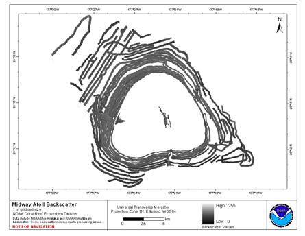
Reson 8101 multibeam backscatter data from portions of the
banktop and bank edge environments at Midway Atoll, Hawaii, USA.
Geospatial_Data_Presentation_Form: digital data
Online_Linkage:
Online_Linkage: https://www.soest.hawaii.edu/pibhmc/cms/
Description:
Abstract:
Multibeam backscatter imagery extracted from gridded
bathymetry of Midway Atoll, Northwestern Hawaiian Islands, USA.
These data provide coverage between 0 and 200 meters. The
backscatter dataset includes data collected using the Reson 8101
multibeam sonar. The sonars frequency is 240 kHz. These metadata
are for the 1 m grid cell size Reson 8101 multibeam backscatter
data only.
Purpose:
The GeoTIFFs of backscatter imagery were created using data
gathered from multibeam soundings for use as a planning and
reference document. The data are also being used for benthic
habitat mapping, for locating Essential Fish Habitat, and for
studying geologic features of the area. Refer to supplemental
information for description of instrument and survey.
Supplemental_Information:
Multibeam data were collected aboard the R/V AHI (Acoustic
Habitat Investigator), a 25' survey launch owned and operated by
the NOAA Pacific Islands Fisheries Science Center in Honolulu,
Hawaii. The R/V AHI's survey sensors include a 240 kHz Reson
8101-ER sonar providing multibeam bathymetry and backscatter
data, a TSS/Applanix POS/MV Model 320 which measures position,
velocity, attitude and heading, and a Seabird SBE 19 CTD used to
measure sound velocity profiles. Specific equipment
configurations are documented in metadata from cruises AHI0306,
HI0503, and HI0609. These metadata can be accessed at:
https://www.soest.hawaii.edu/pibhmc/cms/cruise-catalog/.
Time_Period_of_Content:
Time_Period_Information:
Range_of_Dates/Times:
Beginning_Date: 20030729
Ending_Date: 20060720
Currentness_Reference: ground condition
Status:
Progress: Complete
Maintenance_and_Update_Frequency: As needed
Spatial_Domain:
Bounding_Coordinates:
West_Bounding_Coordinate: -177.502130
East_Bounding_Coordinate: -177.251943
North_Bounding_Coordinate: 28.345964
South_Bounding_Coordinate: 28.157620
Keywords:
Theme:
Theme_Keyword_Thesaurus: NCEI Geoportal Filter
Theme_Keyword: CoRIS_Metadata
Theme:
Theme_Keyword_Thesaurus: CRCP Project
Theme_Keyword:
Benthic Habitat Mapping and Characterization in the Pacific Islands Region
Theme_Keyword: 467
Theme:
Theme_Keyword_Thesaurus: None
Theme_Keyword:
EARTH SCIENCE > Oceans > Bathymetry/Seafloor
Topography > Backscatter
Theme_Keyword: Acoustic Imagery
Theme_Keyword: Multibeam Backscatter
Theme_Keyword: Backscatter
Theme:
Theme_Keyword_Thesaurus: CoRIS Theme Thesaurus
Theme_Keyword:
EARTH SCIENCE > Oceans > Bathymetry/Seafloor Topography > Backscatter
Theme:
Theme_Keyword_Thesaurus: ISO 19115 Topic Category
Theme_Keyword: elevation
Theme_Keyword: 006
Theme_Keyword: environment
Theme_Keyword: 007
Theme_Keyword: geoscientificInformation
Theme_Keyword: 008
Theme_Keyword: imageryBaseMapsEarthCover
Theme_Keyword: 010
Theme:
Theme_Keyword_Thesaurus: CoRIS Discovery Thesaurus
Theme_Keyword: Geographic Information > Backscatter
Place:
Place_Keyword_Thesaurus: None
Place_Keyword: Midway Atoll
Place_Keyword: Hawaii
Place_Keyword: Northwestern Hawaiian Islands
Place_Keyword: United States of America
Place:
Place_Keyword_Thesaurus: CoRIS Place Thesaurus
Place_Keyword:
COUNTRY/TERRITORY > United States of America > Hawaii > Honolulu > Midway Atoll (28N177W0001)
Place_Keyword:
OCEAN BASIN > Pacific Ocean > Central Pacific Ocean > Northwestern Hawaiian Islands > Midway Atoll (28N177W0001)
Place:
Place_Keyword_Thesaurus: CoRIS Region
Place_Keyword: NWHI
Access_Constraints: None
Use_Constraints:
These data are not to be used for navigation purposes.
Please acknowledge NOAA and the Joint Institute for Marine and Atmospheric Research,
University of Hawaii as the sources of this information.
Point_of_Contact:
Contact_Information:
Contact_Organization_Primary:
Contact_Organization:
Pacific Islands Benthic Habitat Mapping Center (PIBHMC), Coral Reef Ecosystem Division (CRED), Pacific Islands Fisheries Science Center (PIFSC), National Marine Fisheries Service (NMFS), National Oceanic and Atmospheric Administration (NOAA)
Contact_Address:
Address_Type: mailing and physical address
Address: NOAA IRC
Address: NMFS/PIFSC/CRED
Address: 1845 WASP Blvd., Building 176
City: Honolulu
State_or_Province: HI
Postal_Code: 96818
Contact_Voice_Telephone: 808 725-5360
Contact_Facsimile_Telephone: 808 725-5429
Contact_Electronic_Mail_Address: nmfs.pic.credinfo@noaa.gov
Contact_Instructions: e-mail preferred
Browse_Graphic:
Browse_Graphic_File_Name:
Browse_Graphic_File_Description:
Multibeam Backscatter,
Acoustic Imagery
Browse_Graphic_File_Type: JPEG
Data_Set_Credit: PIBHMC, CRED, PIFSC, NOAA and JIMAR
Security_Information:
Security_Classification_System: Not applicable
Security_Classification: Unclassified
Security_Handling_Description: Not applicable
Native_Data_Set_Environment:
GeoTIFF and netCDF grid file created
using HMRG software in a LINUX environment