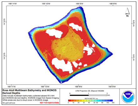
This mosaiced derived bathymetry product (rose_dball2) was then integrated with the multibeam sonar data, with sonar data prioritized over derived data, to create the final product (rose_5m_dbmb), through the following steps.
Initially, grdmath, a Generic Mapping Tools (GMT) algorithm that combines multiple grids, was used to combine the mosaicked derived bathymetry product (rose_dball2) with the gridded multibeam bathymetry (rose_5m). The AND operator was used to prioritize use of the multibeam grid over the derived bathymetry grid, where the two overlapped. The resulting product was found to have a noticeable artifact in the form of a marked step in depth on the bank top, where the derived bathymetry and multibeam bathymetry grids met. To avoid this problem, the final product was created by integrating the mosaic derived bathymetry product (rose_dball2) with an extracted subset of the multibeam data that only covered the inner lagoon. First, Fledermaus 3D Editor was used to extract xyz values from the multibeam data to create a subset covering the inner lagoon (rose_lagoon.xyz). The GMT nearneighbor algorithm was used to create a netCDF grid from the lagoon multibeam data. Secondly, xyz points were extracted from the derived bathymetry product (rose_dball2) using the Sample tool, available in ESRI ArcToolbox. The GMT nearneighbor algorithm was used to create a nearneighbor grid from these data. The two nearneighbor grids (one from the lagoon multibeam bathymetry and one from the mosaiced derived bathymetry product) were combined using grdmath. The AND operator was used to prioritize use of the multibeam grid over the derived bathymetry grid, where the two overlapped. The resulting grid (ros_5m_dbmb.nn.grd) was then converted to ASCII format using LINUX/UNIX commands in combination with GMT. (rose_5m_dmbm.asc). GMT is an open source collection of tools for manipulating geographic data sets. Additional information about GMT can be found at: www.soest.hawaii.edu/gmt