Citation:
Citation_Information:
Originator:
Pacific Islands Benthic Habitat Mapping Center (PIBHMC), Coral Reef Ecosystem Division (CRED), Pacific Islands Fisheries Science Center (PIFSC), National Marine Fisheries Service (NMFS), National Oceanic and Atmospheric Administration (NOAA)
Publication_Date: 20100614
Title:
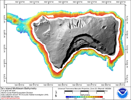
Gridded bathymetry of the banktop and slope environments of Ta'u
Island of the Manu'a Island group, American Samoa (Arc ASCII format)
Geospatial_Data_Presentation_Form: raster digital data
Online_Linkage: http://www.soest.hawaii.edu/pibhmc
Online_Linkage: http://www.soest.hawaii.edu/pibhmc/pibhmc_amsamoa_tau_bathy.htm
Description:
Abstract:
Gridded bathymetry of the banktop and slope environments of Ta'u
Island of the Manu'a Island group, American Samoa. This
survey provides almost complete coverage between 20 and 350 meters.
The multibeam data are from Reson 8101ER system aboard the R/V AHI and were
collected during Jan. to March of 2004.
Purpose:
The data were collected in support of Coral Reef Conservation Program goals
to map all shallow (0-30 m) coral reefs in US Pacific waters and priority
moderate (> 30 m) depth areas by 2009. The data are being used to provide
bathymetric and backscatter data for previously unmapped areas; in support
of ecosystem management requirements for benthic habitat mapping and
location of Essential Fish Habitat; and to study the geologic features of
the area.
Supplemental_Information:
Data were collected aboard the R/V AHI (Acoustic Habitat Investigator),
a 25' survey launch owned and operated by the NOAA Pacific Islands
Fisheries Science Center in Honolulu, HI. The R/V AHI's survey sensors
include a 240 kHz RESON 8101-ER sonar providing bathymetry and imagery
data, a TSS/Applanix POS/MV Model 320 which measures position, velocity,
attitude and heading, and a Seabird SBE 19 CTD used to measure sound
velocity profiles. Sensor configuration for the AHI for cruise
AHI0402 is documented in the cruise/multibeam metadata file
AHI0402_MB_Metadata.txt.
Time_Period_of_Content:
Time_Period_Information:
Range_of_Dates/Times:
Beginning_Date: 20040205
Ending_Date: 20040212
Currentness_Reference: ground condition
Status:
Progress: Complete
Maintenance_and_Update_Frequency: As needed
Spatial_Domain:
Bounding_Coordinates:
West_Bounding_Coordinate: -169.597758
East_Bounding_Coordinate: -169.410175
North_Bounding_Coordinate: -14.186811
South_Bounding_Coordinate: -14.286236
Keywords:
Theme:
Theme_Keyword_Thesaurus: NCEI Geoportal Filter
Theme_Keyword: CoRIS_Metadata
Theme:
Theme_Keyword_Thesaurus: CRCP Project
Theme_Keyword:
Benthic Habitat Mapping and Characterization - American Samoa and PRIA
Theme_Keyword: 1084
Theme:
Theme_Keyword_Thesaurus: ISO 19115 Topic Category
Theme_Keyword: elevation
Theme_Keyword: 006
Theme:
Theme_Keyword_Thesaurus: None
Theme_Keyword: Gridded bathymetry
Theme:
Theme_Keyword_Thesaurus: CoRIS Discovery Thesaurus
Theme_Keyword: Geographic Information > Bathymetry
Theme:
Theme_Keyword_Thesaurus: CoRIS Theme Thesaurus
Theme_Keyword:
EARTH SCIENCE > Oceans > Bathymetry/Seafloor Topography > Bathymetry
Place:
Place_Keyword_Thesaurus: None
Place_Keyword: Ta'u Island
Place_Keyword: Manu'a Islands
Place_Keyword: American Samoa
Place:
Place_Keyword_Thesaurus: CoRIS Place Thesaurus
Place_Keyword:
COUNTRY/TERRITORY > United States of America > American Samoa > American Samoa > Ta'u Island (14S169W0012)
Place_Keyword:
OCEAN BASIN > Pacific Ocean > Manu'a Group > Ta'u Island (14S169W0012)
Place:
Place_Keyword_Thesaurus: CoRIS Region
Place_Keyword: AmSam
Access_Constraints: None
Use_Constraints:
These data are not to be used for navigation purposes.
Please acknowledge the NOAA Coral Reef Ecosystem Division,
Pacific Islands Fisheries Science Center and the Pacific Islands Benthic
Habitat Mapping Center, School of Ocean and Earth Science and Technology, University
of Hawaii as the sources of this information.
Point_of_Contact:
Contact_Information:
Contact_Organization_Primary:
Contact_Organization:
Pacific Islands Benthic Habitat Mapping Center (PIBHMC), Coral Reef Ecosystem Division (CRED), Pacific Islands Fisheries Science Center (PIFSC), National Marine Fisheries Service (NMFS), National Oceanic and Atmospheric Administration (NOAA)
Contact_Person: John Rooney
Contact_Address:
Address_Type: mailing and physical address
Address: NOAA IRC
Address: NMFS/PIFSC/CRED
Address: 1845 WASP Blvd., Building 176
City: Honolulu
State_or_Province: HI
Postal_Code: 96818
Contact_Voice_Telephone: 808 725-5360
Contact_Facsimile_Telephone: 808 725-5429
Contact_Electronic_Mail_Address: nmfs.pic.credinfo@noaa.gov
Contact_Instructions: e-mail preferred
Browse_Graphic:
Browse_Graphic_File_Name:
Browse_Graphic_File_Description: Gridded Bathymetry
Browse_Graphic_File_Type: jpg
Data_Set_Credit:
Benthic Habitat Mapping Group, Coral Reef Ecosystem Division
(CRED), Pacific Islands Fisheries Science Center (PIFSC), NOAA
Security_Information:
Security_Classification_System: Not applicable
Security_Classification: Unclassified
Security_Handling_Description: Not applicable