Abstract:
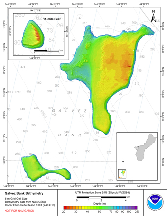
Gridded bathymetry (5m) of the bank environment of Galvez Bank, and 2 small nearby banks
S. Galvez Bank (~ 3 nmi south of Galvez) and 11-mile Reef (~ 5 nmi north of Galvez, 11 nmi west of Guam),
Territory of Guam, USA. These netCDF and ASCII grids includes multibeam bathymetry from the
Reson 8101 multibeam sonar aboard the NOAA Ship Oscar E. Sette collected as of May 2010 by the NOAA Coral
Reef Ecosystem Division in depths between 10 and 300 meters.
Purpose:
These netCDF and ASCII grids were created using data gathered from multibeam soundings for use as a
planning and reference document. The data are also being used for benthic habitat
mapping, for locating Essential Fish Habitat, and for studying geologic features of
the area. Refer to supplemental information for description of instrument and survey.
Supplemental_Information:
Multibeam data were collected aboard the NOAA Ship Oscar Elton Sette, a 224' (68 m) United States
National Oceanographic and Atmospheric Administration research ship. The NOAA Ship
Sette's survey sensors included a 240-kHz pole-mounted Reson 8101ER sonar, which provides
bathymetry and imagery data, a TSS/Applanix POS/MV Model 320, which measures position,velocity, attitude and heading, and a Seabird SBE19 CTD used to measure sound velocity profiles.
Specific equipment configurations are documented in metadata from cruise
SE1002. These metadata can be accessed at:
https://www.soest.hawaii.edu/pibhmc/cms/cruise-catalog/
Raster_Object_Information gal_5m_100m
Raster_Object_Type Grid Cell
Row_Count 1869
Column_Count 1623
Vertical_Count 1
Raster_Object_Information sgal5m
Raster_Object_Type Grid Cell
Row_Count 905
Column_Count 1293
Vertical_Count 1
Raster_Object_Information ngal5m
Raster_Object_Type Grid Cell
Row_Count 357
Column_Count 307
Vertical_Count 1
Theme:
Theme_Keyword_Thesaurus: NCEI Geoportal Filter
Theme_Keyword: CoRIS_Metadata
Theme:
Theme_Keyword_Thesaurus: CRCP Project
Theme_Keyword:
Benthic Habitat Mapping and Characterization - Commonwealth of the Northern Mariana Islands and Guam
Theme_Keyword: 1398
Theme:
Theme_Keyword_Thesaurus: CoRIS Theme Thesaurus
Theme_Keyword:
EARTH SCIENCE > Oceans > Bathymetry/Seafloor Topography > Bathymetry
Theme:
Theme_Keyword_Thesaurus: ISO 19115 Topic Category
Theme_Keyword: elevation
Theme_Keyword: 006
Theme:
Theme_Keyword_Thesaurus: CoRIS Discovery Thesaurus
Theme_Keyword: Geographic Information > Bathymetry
Theme:
Theme_Keyword_Thesaurus: None
Theme_Keyword: Bathymetry
Theme_Keyword: Multibeam sonar
Place:
Place_Keyword_Thesaurus: None
Place_Keyword: Galvez Bank
Place_Keyword: Territory of Guam
Place_Keyword: United States of America
Place:
Place_Keyword_Thesaurus: None
Place_Keyword: S. Galvez Bank
Place_Keyword: Territory of Guam
Place_Keyword: United States of America
Place:
Place_Keyword_Thesaurus: None
Place_Keyword: 11-Mile Reef
Place_Keyword: Territory of Guam
Place_Keyword: United States of America
Place:
Place_Keyword_Thesaurus: CoRIS Place Thesaurus
Place_Keyword:
COUNTRY/TERRITORY > United States of America > Guam > Galvez Bank (13N144E0049)
Place_Keyword:
OCEAN BASIN > Pacific Ocean > Western Pacific Ocean > Guam > Galvez Bank (13N144E0049)
Place_Keyword:
OCEAN BASIN > Pacific Ocean > Western Pacific Ocean > Guam > Eleven Mile Reef (13N144E0059)
Place_Keyword:
COUNTRY/TERRITORY > United States of America > Guam > Eleven Mile Reef (13N144E0059)
Place_Keyword:
OCEAN BASIN > Pacific Ocean > Western Pacific Ocean > Guam > South Galvez Bank (13N144E0060)
Place_Keyword:
COUNTRY/TERRITORY > United States of America > Guam > South Galvez Bank (13N144E0060)
Place_Keyword:
COUNTRY/TERRITORY > United States of America > Guam > Guam (13N144E0000)
Place_Keyword:
OCEAN BASIN > Pacific Ocean > Western Pacific Ocean > Guam > Guam (13N144E0000)
Place:
Place_Keyword_Thesaurus: CoRIS Region
Place_Keyword: Guam
These data are not to be used for navigation purposes.
Please acknowledge NOAA and the Joint Institute for Marine and Atmospheric Research (JIMAR)
University of Hawaii as the sources of this information.
netCDF file created using the Generic
Mapping Tools (GMT) and ArcGIS ASCII file, both created in a
LINUX environment