Citation:
Citation_Information:
Originator:
Pacific Islands Benthic Habitat Mapping Center (PIBHMC), Coral Reef Ecosystem Division (CRED), Pacific Islands Fisheries Science Center (PIFSC), National Marine Fisheries Service (NMFS), National Oceanic and Atmospheric Administration (NOAA)
Publication_Date: 20121225
Title:
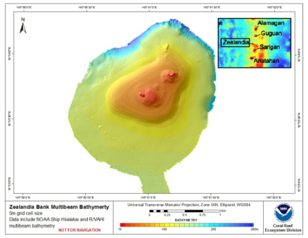
Gridded multibeam bathymetry of Zealandia Bank,
Commonwealth of the Northern Mariana Islands (CNMI).
Geospatial_Data_Presentation_Form: digital data
Online_Linkage:
Online_Linkage: https://www.soest.hawaii.edu/pibhmc/cms/
Description:
Abstract:
Gridded bathymetry shelf, bank and slope environments of
Zealandia Bank, CNMI. Bottom coverage was achieved in depths
between ~12 and 285 meters, The Arc ASCII grid includes multibeam
bathymetry from the Simrad EM300 and Reson 8101 multibeam sonars
collected as of June 2007 by the NOAA Coral Reef Ecosystem
Division. The sonar frequencies are 30 and 240 kHz respectively.
Purpose:
The ASCII grid was created using data gathered
from multibeam soundings for use as a planning and reference
document. The data are also being used for benthic habitat
mapping, for locating Essential Fish Habitat, and for studying
geologic features of the area. Refer to supplemental information
for description of instrument and survey.
Supplemental_Information:
Multibeam data were collected aboard the NOAA Ship Hi'ialakai, a
218' United States National Oceanographic and Atmospheric
Administration research ship. The NOAA Ship Hi'ialakai's survey
sensors include a 30 kHz Simrad EM300 sonar and a 300 kHz Simrad
EM3002d sonar, which provide bathymetry and imagery data, a
TSS/Applanix POS/MV Model 320, which measures position, velocity,
attitude and heading, and a Seabird SBE 9/11 plus CTD used to
measure sound velocity profiles.
Multibeam data were also collected aboard the R/V AHI (Acoustic
Habitat Investigator), a 25' survey launch owned and operated by
the NOAA Pacific Islands Fisheries Science Center in Honolulu,
HI. The R/V AHI's survey sensors include a 240 kHz RESON 8101-ER
sonar providing bathymetry and imagery data, a TSS/Applanix
POS/MV Model 320 which measures position, velocity, attitude and
heading, and a Seabird SBE 19 CTD used to measure sound velocity
profiles.
Specific equipment configurations are documented in metadata from
cruises AHI0703 and HI0703. These metadata can be accessed at:
https://www.soest.hawaii.edu/pibhmc/cms/cruise-catalog/
Time_Period_of_Content:
Time_Period_Information:
Range_of_Dates/Times:
Beginning_Date: 20070525
Ending_Date: 20070608
Currentness_Reference: ground condition
Status:
Progress: Complete
Maintenance_and_Update_Frequency: As needed
Spatial_Domain:
Bounding_Coordinates:
West_Bounding_Coordinate: 145.839
East_Bounding_Coordinate: 145.859
North_Bounding_Coordinate: 16.904
South_Bounding_Coordinate: 16.868
Keywords:
Theme:
Theme_Keyword_Thesaurus: NCEI Geoportal Filter
Theme_Keyword: CoRIS_Metadata
Theme:
Theme_Keyword_Thesaurus: CRCP Project
Theme_Keyword:
Benthic Habitat Mapping and Characterization in the Pacific Islands Region
Theme_Keyword: 467
Theme:
Theme_Keyword_Thesaurus: CoRIS Theme Thesaurus
Theme_Keyword:
EARTH SCIENCE > Biosphere > Zoology > Corals > Reef Monitoring and Assessment > Mapping > geomorphology Mapping
Theme_Keyword:
EARTH SCIENCE > Biosphere > Aquatic Habitat > Reef Habitat > Description
Theme_Keyword:
EARTH SCIENCE > Oceans > Bathymetry/Seafloor Topography > Bathymetry
Theme:
Theme_Keyword_Thesaurus: ISO 19115 Topic Category
Theme_Keyword: elevation
Theme_Keyword: 006
Theme:
Theme_Keyword_Thesaurus: CoRIS Discovery Thesaurus
Theme_Keyword: Geographic Information > Bathymetry
Place:
Place_Keyword_Thesaurus: None
Place_Keyword: Zealandia Bank
Place_Keyword: Commonwealth of the Northern Mariana Islands
Place_Keyword: United States of America
Place:
Place_Keyword_Thesaurus: CoRIS Place Thesaurus
Place_Keyword:
OCEAN BASIN > Pacific Ocean > Western Pacific Ocean > Mariana Islands > Zealandia Bank (16N145E0005)
Place_Keyword:
COUNTRY/TERRITORY > Northern Mariana Islands > Northern Mariana Islands > Zealandia Bank (16N145E0005)
Place:
Place_Keyword_Thesaurus: CoRIS Region
Place_Keyword: CNMI
Access_Constraints: None
Use_Constraints:
These data are not to be used for navigation purposes. Please acknowledge the NOAA Pacific Islands Fisheries
Science Center (PIFSC) Coral Reef Ecosystem Division (CRED) and
the Pacific Islands Benthic Habitat Mapping Center, and the Joint
Institute for Marine and Atmospheric Research (JIMAR) and School
of Ocean and Earth Science and Technology (SOEST), University of
Hawaii as the sources of this information.
Point_of_Contact:
Contact_Information:
Contact_Organization_Primary:
Contact_Organization:
Pacific Islands Benthic Habitat Mapping Center (PIBHMC), Coral Reef Ecosystem Division (CRED), Pacific Islands Fisheries Science Center (PIFSC), National Marine Fisheries Service (NMFS), National Oceanic and Atmospheric Administration (NOAA)
Contact_Address:
Address_Type: mailing and physical
Address: NOAA IRC
Address: NMFS/PIFSC/CRED
Address: 1845 WASP Blvd., Building 176
City: Honolulu
State_or_Province: HI
Postal_Code: 96818
Country: USA
Contact_Voice_Telephone: 808 725-5360
Contact_Electronic_Mail_Address: nmfs.pic.credinfo@noaa.gov
Contact_Instructions: e-mail preferred
Browse_Graphic:
Browse_Graphic_File_Name:
Browse_Graphic_File_Description: Gridded Bathymetry Derivative
Browse_Graphic_File_Type: JPEG
Data_Set_Credit: NOAA PIFS, CRED, PIBHMC, JIMAR, and SOEST
Security_Information:
Security_Classification_System: Not applicable
Security_Classification: Unclassified
Security_Handling_Description: Not applicable
Native_Data_Set_Environment: ArcGIS ASCII file, derived from bathymetry in ArcGIS 10.1