Citation:
Citation_Information:
Originator:
Pacific Islands Benthic Habitat Mapping Center (PIBHMC), Coral Reef Ecosystem Division (CRED), Pacific Islands Fisheries Science Center (PIFSC), National Marine Fisheries Service (NMFS), National Oceanic and Atmospheric Administration (NOAA)
Publication_Date: 20111012
Title:
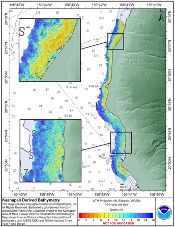
Derived bathymetry of nearshore benthic habitats near Kaanapali, Maui, Hawaii
Online_Linkage:
Description:
Abstract:
Methods used were adapted from a "cookbook" of instructions developed by Kyle Hogref
for using IKONOS imagery data to derive seafloor elevations in optically clear
water. This dataset was derived from high-resolution (2 m) imagery from DigitalGlobe's
WorldView-2 sensor of the Kaanapali area of Maui, Hawaii. Sensor bands 1,2
and 5 (coastal, blue and near IR respectively) were used to derive depth information.
The method assumes uniform water clarity but deviations from that condition
made extraction difficult in water greater than 30 m depth in the Kaanapali scene
used. Results show that biotic material or sediment in the water column skewed results
shallower if the material has a high albedo and deeper if the material has a low
albedo. Nearshore areas were significantly less impacted in the Kaanapali area,
due to the geomorphology of the area and the hi resolution and quality of the imagery,
allowing visual descrimination of apparent sediment in the water column.
For presentation purposes the map product shows an Inverse Distance Weighted interpolated
bathymetry surface, restricted to data within 600 m of the shoreline.
Purpose:
DG WorldView-2 data are used as the base imagery to derived pseudobathymetry of the
Kaanapali area of Maui. This area has both SHOALS and multi-beam acoustic derived
bathymetry coverage and will provide an example case of the strengths and
weaknesses of pseudobathymetry extraction from high resolution satellite imagery methods.
Supplemental_Information:
LiDAR bathymetry of Kaanapali, Maui from Scanning Hydrographic Airborne Operational
LiDAR data from the United States Army Corps of Engineers Joint Airborne LiDAR
Bathymertry Technical Center for Expertise. Multibeam sonar data from the
Main Hawaiian Islands Bathymetry synthesis maintained by the Hawaii Mapping Research Group
at the University of Hawaii, School of Ocean and Earth Science and Technology.
Time_Period_of_Content:
Time_Period_Information:
Range_of_Dates/Times:
Beginning_Date: 20100406
Ending_Date: 20100406
Currentness_Reference: ground condition
Status:
Progress: Complete
Maintenance_and_Update_Frequency: As needed
Spatial_Domain:
Bounding_Coordinates:
West_Bounding_Coordinate: -156.7760
East_Bounding_Coordinate: -156.6470
North_Bounding_Coordinate: 20.9839
South_Bounding_Coordinate: 20.8357
Keywords:
Theme:
Theme_Keyword_Thesaurus: NCEI Geoportal Filter
Theme_Keyword: CoRIS_Metadata
Theme:
Theme_Keyword_Thesaurus: CRCP Project
Theme_Keyword:
M218 Benthic Habitat Mapping and Characterization in the Pacific Islands Region
Theme_Keyword: 1217
Theme:
Theme_Keyword_Thesaurus: CoRIS Theme Thesaurus
Theme_Keyword:
EARTH SCIENCE > Oceans > Bathymetry/Seafloor Topography > Bathymetry
Theme:
Theme_Keyword_Thesaurus: None
Theme_Keyword: Bathymetry
Theme_Keyword: Multibeam sonar
Theme:
Theme_Keyword_Thesaurus: ISO 19115 Topic Category
Theme_Keyword: elevation
Theme_Keyword: 006
Theme:
Theme_Keyword_Thesaurus: CoRIS Discovery Thesaurus
Theme_Keyword: Geographic Information > Bathymetry
Place:
Place_Keyword_Thesaurus: None
Place_Keyword: Maui
Place_Keyword: Main Hawaiian Islands
Place_Keyword: United States of America
Place:
Place_Keyword_Thesaurus: CoRIS Place Thesaurus
Place_Keyword:
OCEAN BASIN > Pacific Ocean > Central Pacific Ocean > Hawaiian Islands > Maui Island > Maui Island (20N156W0004)
Place_Keyword:
COUNTRY/TERRITORY > United States of America > Hawaii > Maui > Maui Island (20N156W0004)
Place:
Place_Keyword_Thesaurus: CoRIS Region
Place_Keyword: MHI
Access_Constraints: none
Use_Constraints:
These data are not to be used for navigation purposes. Please acknowledge the NOAA Pacific Islands Fisheries Science Center,
and the Joint Institute for Marine and Atmospheric Research (JIMAR) and Hawaii
Mapping Research Group (HMRG) at the University of Hawaii as the sources of
this information.
Point_of_Contact:
Contact_Information:
Contact_Organization_Primary:
Contact_Organization:
Pacific Islands Benthic Habitat Mapping Center (PIBHMC), Coral Reef Ecosystem Division (CRED), Pacific Islands Fisheries Science Center (PIFSC), National Marine Fisheries Service (NMFS), National Oceanic and Atmospheric Administration (NOAA)
Contact_Address:
Address_Type: mailing and physical address
Address: NOAA IRC
Address: NMFS/PIFSC/CRED
Address: 1845 WASP Blvd., Building 176
City: Honolulu
State_or_Province: HI
Postal_Code: 96818
Contact_Voice_Telephone: 808 725-5360
Contact_Facsimile_Telephone: 808 725-5429
Contact_Electronic_Mail_Address: nmfs.pic.credinfo@noaa.gov
Contact_Instructions: e-mail preferred
Browse_Graphic:
Browse_Graphic_File_Name:
Browse_Graphic_File_Description: Layout of data on original satellite imagery
Browse_Graphic_File_Type: JPEG
Data_Set_Credit: PIBHMC, CRED, PIFSC, NOAA, JIMAR and HMRG
Security_Information:
Security_Classification_System: Not applicable
Security_Classification: Unclassified
Security_Handling_Description: Not applicable
Native_Data_Set_Environment:
netCDF file created using the Generic
Mapping Tools (GMT) and ArcGIS ASCII file, both created in a
LINUX environment