Citation:
Citation_Information:
Originator:
Pacific Islands Benthic Habitat Mapping Center (PIBHMC), Coral Reef Ecosystem Division (CRED), Pacific Islands Fisheries Science Center (PIFSC), National Marine Fisheries Service (NMFS), National Oceanic and Atmospheric Administration (NOAA)
Originator:
NOAA National Centers for Coastal Ocean Science (NCCOS) Biogeography Branch
Publication_Date: 20120601
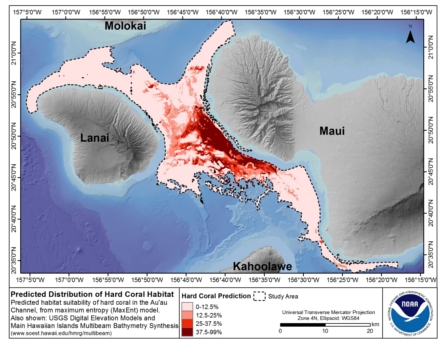
Title:
Predicted Habitat Suitability for All Mesophotic Corals in the Au'au Channel Region
Online_Linkage:
Description:
Abstract:
This dataset is located between the islands of Maui, Lanai, Molokai and Kahoolawe, and includes
the Au'au Channel as well as parts of the Kealaikahiki, Alalakeiki and Kalohi Channels.
This map denotes predicted habitat suitability for all mesophotic corals in the Au'au Channel
region. Maximum Entropy (MaxEnt) modeling software was used to create this ensemble model, which
is an average of 10 model replicates. MaxEnt works by analyzing the distribution of environmental
variables where species are present, so it can find other areas that meet all of the same
environmental constraints. Georeferenced records containing information about mesophotic coral
occurrence and environmental predictors describing the seafloors depth, vertical structure,
available light, surface temperature, currents and distance from shoreline were used to train MaxEnt.
Model performance and accuracy were assessed using Receiver Operating Characteristic (ROC) Area Under
the Curve (AUC) and a randomly chosen, spatially independent data subset. The average test AUC for
this predictive ensemble model was 0.9, and the overall accuracy of this ensemble predictive model
was 73.1% (when the habitat suitability threshold = 0.25). The habitat suitability threshold of
0.25 represents the sum of the maximum ROC sensitivity and specificity values. Extreme care should
be taken when selecting a habitat suitability threshold because it affects the probability of
correctly identifying the presence and absence of mesophotic corals. For more information describing
how this predictive surface was developed and its limitations, please see the following website:
https://coastalscience.noaa.gov/project/modeling-mesophotic-coral-distributions-auau-channel-hawaii/
This dataset describes the predicted distribution of all mesophotic corals in the Au'au Channel
region in the Main Hawaiian Islands (MHI). Mesophotic hard corals are light-dependent corals adapted
to the low light conditions at approximately 30 to 150 m in depth. Several physical factors potentially
influence their spatial distribution, including aragonite saturation, alkalinity, pH, currents, water
temperature, hard substrate availability and the availability of light at depth. Mesophotic corals and
mesophotic coral ecosystems (MCEs) have increasingly been the subject of scientific study because
they are being threatened by a growing number of anthropogenic stressors. They are the focus of this
spatial modeling effort because the Hawaiian Islands Humpback Whale National Marine Sanctuary (HIHWNMS)
is exploring the expansion of its scope beyond the protection of the North Pacific Humpback Whale
(Megaptera novaeangliae)to include the conservation and management of these ecosystem components.
The present study helps to address this need by examining the distribution of mesophotic corals in
the Au'au Channel region.
Supplemental_Information:
This map presents data published in the following report: Costa, B.M., M.S. Kendall, J. Rooney, M. Chow,
J. Lecky, F.A. Parrish, A. Montgomery, R.C. Boland, and H. Spalding. 2012. Prediction of Mesophotic Coral
Distributions in the Au'au Channel, Hawaii. NOAA Technical Memorandum NOS NCCOS 149. Prepared by the NCCOS
Center for Coastal Monitoring and Assessment Biogeography Branch. Silver Spring, MD. 44 pp., available
on
https://coastalscience.noaa.gov/project/modeling-mesophotic-coral-distributions-auau-channel-hawaii/
Time_Period_of_Content:
Time_Period_Information:
Range_of_Dates/Times:
Beginning_Date: 20120208
Ending_Date: 20120208
Currentness_Reference: ground condition
Status:
Progress: Complete
Maintenance_and_Update_Frequency: As needed
Spatial_Domain:
Bounding_Coordinates:
West_Bounding_Coordinate: -157.155969
East_Bounding_Coordinate: -156.159430
North_Bounding_Coordinate: 21.089436
South_Bounding_Coordinate: 20.459897
Keywords:
Theme:
Theme_Keyword_Thesaurus: NCEI Geoportal Filter
Theme_Keyword: CoRIS_Metadata
Theme:
Theme_Keyword_Thesaurus: CRCP Project
Theme_Keyword: 467
Theme_Keyword:
Benthic Habitat Mapping and Characterization in the Pacific Islands Region
Theme:
Theme_Keyword_Thesaurus: CoRIS Discovery Thesaurus
Theme_Keyword: Map Images > Habitats
Theme:
Theme_Keyword_Thesaurus: CoRIS Theme Thesaurus
Theme_Keyword:
EARTH SCIENCE > Biosphere > Zoology > Corals > Photic Zone Corals
Theme_Keyword: EARTH SCIENCE > Oceans > Coastal Processes > Coral Reefs
Theme_Keyword:
EARTH SCIENCE > Oceans > Coastal Processes > Coral Reefs > Coral Reef Ecology > Habitats
Theme_Keyword:
EARTH SCIENCE > Oceans > Coastal Processes > Coral Reefs > Coral Reef Ecology > Hard Coral Cover
Theme_Keyword: EARTH SCIENCE > Biosphere > Aquatic Habitat > Reef Habitat
Theme_Keyword:
EARTH SCIENCE > Biosphere > Zoology > Corals > Reef Monitoring and Assessment > Mapping
Theme_Keyword:
EARTH SCIENCE > Biosphere > Zoology > Corals > Reef Monitoring and Assessment > Mapping > Habitat Mapping
Theme_Keyword:
EARTH SCIENCE > Oceans > Coastal Processes > Coral Reefs > Marine Protected Areas
Theme:
Theme_Keyword_Thesaurus: ISO 19115 Topic Category
Theme_Keyword: biota
Theme_Keyword: 002
Theme_Keyword: environment
Theme_Keyword: 007
Theme_Keyword: oceans
Theme_Keyword: 014
Place:
Place_Keyword_Thesaurus: None
Place_Keyword: Maui
Place_Keyword: Main Hawaiian Islands
Place_Keyword: United States of America
Place:
Place_Keyword_Thesaurus: CoRIS Place Thesaurus
Place_Keyword:
OCEAN BASIN > Pacific Ocean > Central Pacific Ocean > Hawaiian Islands (21N157W0027)
Place_Keyword:
OCEAN BASIN > Pacific Ocean > Central Pacific Ocean > Hawaiian Islands > Auau Channel > AuAu Channel (20N156W0027)
Place_Keyword:
OCEAN BASIN > Pacific Ocean > Central Pacific Ocean > Hawaiian Islands > Maui Island > Maui Island (20N156W0004)
Place_Keyword:
COUNTRY/TERRITORY > United States of America > Hawaii > Maui > Maui Island (20N156W0004)
Place_Keyword:
COUNTRY/TERRITORY > United States of America > Hawaiian Islands (21N157W0027)
Place_Keyword:
COUNTRY/TERRITORY > United States of America > Hawaii > Auau Channel > AuAu Channel (20N156W0027)
Place:
Place_Keyword_Thesaurus: CoRIS Region
Place_Keyword: MHI
Access_Constraints: none
Use_Constraints:
These data were prepared by an agency of the United States Government. Neither the United States Government
nor any agency thereof, nor any of their employees, make any warranty, expressed or implied, or assumes any legal liability or
responsibility for the accuracy, completeness, or usefulness of any information, apparatus, product, or process disclosed in
this report, or represents that its use would not infringe privately owned rights. Reference therein to any specific commercial
product, process, or service by trade name, trademark, manufacturer, or otherwise does not necessarily constitute or imply its
endorsement, recommendation, or favoring by the United States Government or any agency thereof. Any views and opinions of
authors expressed herein do not necessarily state or reflect those of the United States Government or any agency thereof. No
warranty, expressed or implied, is made by the U.S. Government as to the accuracy of the data and/or related materials.
The act of distribution shall not constitute any such warranty, and no responsibility is assumed by the U.S. Government in the
use of these data or related materials.
Point_of_Contact:
Contact_Information:
Contact_Organization_Primary:
Contact_Organization:
Pacific Islands Benthic Habitat Mapping Center (PIBHMC), Coral Reef Ecosystem Division (CRED), Pacific Islands Fisheries Science Center (PIFSC), National Marine Fisheries Service (NMFS), National Oceanic and Atmospheric Administration (NOAA)
Contact_Address:
Address_Type: mailing and physical
Address: NOAA IRC
Address: NMFS/PIFSC/CRED
Address: 1845 WASP Blvd., Building 176
City: Honolulu
State_or_Province: HI
Postal_Code: 96818
Country: USA
Contact_Voice_Telephone: 808 725-5360
Contact_Electronic_Mail_Address: nmfs.pic.credinfo@noaa.gov
Contact_Instructions: e-mail preferred
Browse_Graphic:
Browse_Graphic_File_Name:
Browse_Graphic_File_Description: Layout of data on background bathymetry
Browse_Graphic_File_Type: JPEG
Data_Set_Credit: PIBHMC, CRED, PIFSC, NOAA, JIMAR, NCCOS, CCMA, and HMRG
Security_Information:
Security_Classification_System: Not applicable
Security_Classification: Unclassified
Security_Handling_Description: Not applicable