This site has been replaced by https://coralreef.noaa.gov/digital-corals/. Please bookmark the new page. You will no longer be able to access this site (CoRIS) after 02/23/2026.
American Samoa Coatal Use Mapping Project - Study Area
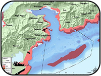
Fagaloa Coastal Uses
The American Samoa Coastal Use Mapping project conducted in Pago Pago, American Samoa in July 2012. Data was obtained through a participatory GIS workshop designed to gather spatial data on human uses of the coastal and nearshore marine environment in the greater Pago Pago Harbor region known as Fagaloa. The project was intended to fill a critical information gap regarding the spatial distribution of human activities in the American Samoa Coral Reef Strategy priority site in order to better inform planning and management activities.
This effort was undertaken as a partnership between multiple agencies including NOAA Pacific Islands Regional Office (PIRO), NOAA Pacific Services Center (PSC), American Samoa Department of Commerce Coastal Management Program (ASCMP), the American Samoa Department of Marine and Wildlife Resources (DMWR) and American Samoa Environmental Protection Agency (ASEPA). Primary funding for the project is from NOAA´s Coral Reef Conservation Program, with inkind support from NOAA Pacific Services Center.
A total of 47 workshop participants, as well as facilitators were involved during the three workshop days. Participants were selected based on their expertise in the various human uses and activities occurring in this region. They represented a wide range of backgrounds relating to marine resources: resource stewards, fishermen, tourism industry experts, natural resource managers, educators, cultural practitioners, scientists, residents, and local business owners.
Targeted Uses
Twenty-three different coastal uses were mapped during the workshop, representing fishing and village based activities, recreation activities and industrial activities. These uses are defined in detail on the Uses List on the following pages. Each use was determined and defined with assistance from local stakeholders and resource managers.
Maps
Data compiled during the workshop were processed to create maps documenting the use patterns as drawn by the workshop participants. After initial data processing was completed, draft maps were presented back to workshop participants to review and provide feedback for final revisions. The following maps show the final patterns for each fishing and recreation use mapped in the workshops as well as a compilation of the supplemental data provided by participants throughout the mapping process. The industrial uses were mapped together. These maps include landside and dock facilities related to all industrial uses.