noaa.gov

Interdisciplinary Baseline Ecosystem Assessment Surveys to Inform Ecosystem-Based Management Planning in Timor-Leste

The datasets collected or generated by the NOAA Coral Reef Ecosystem Program for Timor-Leste as described in the Interdisciplinary Baseline Ecosystem Assessment Surveys to Inform Ecosystem-Based Management Planning in Timor-Leste: Final Report are organized below according to the corresponding data chapters (Chapters 2-4) in the report (Satellite Mapping, Coral Reef Ecosystem Assessments, and Ecological Baselines for Climate Change, respectively).

Click on the thumbnail images to view the full-sized version of the images.

For each dataset, a brief description is provided along with links to view the data documentation (metadata) in InPort (the NOAA Fisheries Enterprise Data Management Program) and to download the data from the NOAA National Centers for Environmental Information (NCEI) data archive.
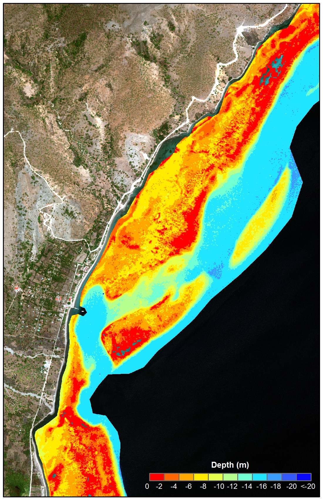
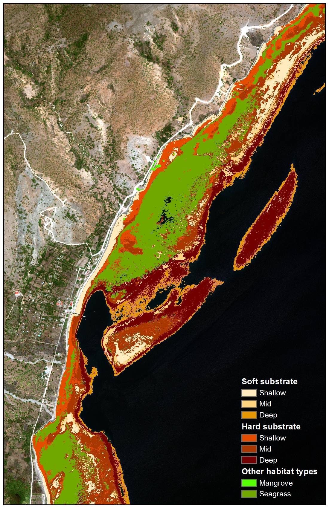
Satellite Mapping

SATELLITE MAPPING Contains the satellite mapping datasets described in Chapter 2.
Image Catalog:  satellite image inventory in ESRI geodatabase format

WorldView-2 satellite image inventory in ESRI geodatabase format (GDB), and includes all images purchased, as well as the image footprints and regions of interest used to define the geographic areas to acquire the satellite imagery. The attributes indicate if the images were georeferenced and used to derive depths and habitat classes.


Data documentation: https://inport.nmfs.noaa.gov/inport/item/46151

Data Access: NCEI Accession 0168914

Bathymetry: Bathymetry data derived from the WorldView-2 satellite imagery

Bathymetry data derived from the WorldView-2 satellite imagery.


Data documentation: https://inport.nmfs.noaa.gov/inport/item/46150

Data Access: NCEI Accession 0169504

Ground Truth: Ground truth data used to validate the depths derived from the WorldView-2 imagery.

Ground truth data used to validate the depths derived from the WorldView-2 imagery.


Data documentation: https://inport.nmfs.noaa.gov/inport/item/25307

Data Access: https://maps.ngdc.noaa.gov/viewers/geophysics/

Within the Trackline Geophysical Data Portal website use the filter by survey ID feature to locate the following surveys from Timor Leste SBP1215 and SBP1310

Benthic Habitat: Benthic habitat data derived from the WorldView-2 satellite imagery.

Benthic habitat data derived from the WorldView-2 satellite imagery.

Data documentation: https://inport.nmfs.noaa.gov/inport/item/29128

Data Access: NCEI Accession 0168914

Coral Reef Ecosystem Assessments

CORAL REEF ECOSYSTEM ASSESSMENTS Contains the datasets from the coral reef ecosystem assessment surveys in 2013 described in Chapter 3.
Fish Surveys: infographic of fish survey

Reef fish and benthic estimate data from visual surveys conducted in 2013.

Data documentation:
https://inport.nmfs.noaa.gov/inport/item/32998

Data Access: NCEI Accession 0165354

Benthic Images: Photographs of the seafloor (photo quadrat) collected during the fish surveys.

Photographs of the seafloor (photo quadrat) collected during the fish surveys.


Data documents: https://inport.nmfs.noaa.gov/inport/item/46160

Data Access: NCEI Accession 0166378

Benthic Cover: Benthic cover data derived from the analysis of the benthic images collected during the fish surveys.

Benthic cover data derived from the analysis of the benthic images collected during the fish surveys.


Data documentation: https://inport.nmfs.noaa.gov/inport/item/46161

Data Access: NCEI Accession 0168620

Ecological Baselines for Climate Change

ECOLOGICAL BASELINES FOR CLIMATE CHANGE Contains the baseline datasets collected from the Climate Monitoring sites from 2012 to 2014 described in Chapter 4.
Temperature: Temperature data from Surface Temperature Records(STRs).

Temperature data from subsurface temperature recorders (STRs).


Data documentation: https://inport.nmfs.noaa.gov/inport/item/46164

Data Access: NCEI Accession 0168931

Seawater Chemistry: Seawater chemistry data from seawater samples.

Seawater chemistry data from seawater samples.


Data documentation: https://inport.nmfs.noaa.gov/inport/item/46163

Data Access: NCEI Accession 0168915

Calcification Rates: photograph of diver on calcified corals

Calcification rate data from calcification accretion units (CAUs).


Data documentation: https://inport.nmfs.noaa.gov/inport/item/46162

Data Access: Contact NCEI Accession 0170031

Biodiversity: Marine invertebrate biodiversity data from autonomous reef monitoring structures (ARMS).

Marine invertebrate biodiversity data from autonomous reef monitoring structures (ARMS).


Data documentation:  https://inport.nmfs.noaa.gov/inport/item/46159

Data Access: NCEI Accession 0169338

Benthic Images: Photographs of the seafloor (photo quadrat) collected at the Climate Monitoring

Photographs of the seafloor (photo quadrat) collected at the Climate Monitoring sites.


Data documentation: https://inport.nmfs.noaa.gov/inport/item/46160

Data Access: NCEI Accession 0166378

Benthic Cover:Benthic cover data derived from the analysis of the benthic images collected in 2014.

Benthic cover data derived from the analysis of the benthic images collected in 2014 at the Climate Monitoring sites.


Data documentation: https://inport.nmfs.noaa.gov/inport/item/46161

Data Access: NCEI Accession 0168620