noaa.gov

Commonwealth of the Northern Mariana Islands (CNMI)

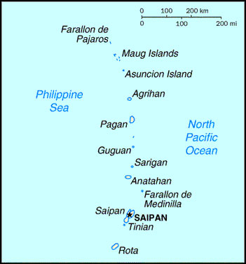
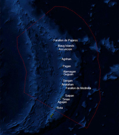
Located just north of Guam in the western Pacific, the Commonwealth of the Northern Mariana Islands is a three-hundred mile archipelago consisting of 14 islands, with a total land area of 183.5 square miles. The principal inhabited islands are Saipan, Guguan, Rota and Tinian. The northern, largely uninhabited islands are Farallon de Medinilla, Anatahan, Sariguan, Gudgeon, Alamagan, Pagan, Agrihan, Asuncion, Maug Islands, and Farallon de Pajaro. Saipan is approximately 3,300 miles west-southwest of Honolulu and 3000 miles north of Sydney. The majority of the CNMI's residents live on Rota, Tinian, and Saipan, the capital and largest of the Northern Mariana Islands.

The Mariana Islands are on the edge of the Philippine Plate. They were formed by underwater volcanoes along the Marianas Trench. The northern islands are high volcanic islands and the southern islands, while volcanic in origin, are capped by uplifted limestone derived from coral reefs. The southern islands have the oldest and most developed reefs in the CNMI, which are predominantly located along the western (leeward) sides.

Saipan has the most diverse types of coral reefs and associated habitats in the CNMI. A fringing and barrier reef system protects the majority of the beaches along the western side of the island, forming a 12.4 square mile shallow-water lagoon system. This environment contains large assemblages of seagrass, branching corals, and the last remaining mangroves in the CNMI. The western side of the island is the most populated and the coral reefs along these areas are negatively affected by human activity. Continuing sediment and nutrient pollution, combined with sporadic stressors such as outbreaks of crown-of-thorns starfish (COTS) and bleaching, affect many of Saipan's western and southeastern reefs. These impacts are compounded by an expanding tourism industry and direct damage from heavy visitor use.

Coral reef ecosystems in the CNMI are, on the whole, reasonably healthy. However, environmental stressors acting along with anthropogenic stressors, such as nonpoint source pollution and fishing pressure, have clearly affected areas in proximity to the populated southern islands. From a fisheries perspective, the northern islands and more distant banks and reefs appear to be in better condition than those closer to population centers.

Commonwealth of the Northern Mariana Islands location map

Commonwealth of the Northern Mariana Islands location map

Northern Mariana Islands satellite map

Northern Mariana Islands satellite map

Highlights

OCM Coastal Impact Stories: Coral Reef Conservation Program in CNMI

Coral Reef Condition: A Status Report for the Commonwealth of the Northern Mariana Islands (2018)

NCCOS Assessment: Benthic Habitat Maps of Saipan Lagoon (2017)

National Coral Reef Monitoring Program Socioeconomic Monitoring Component Summary Findings for CNMI (2016)

Publications

CNMI's Coral Reef Management Priorities (2010)

CNMI Capacity Assessment Report and Coral Reef Conservation Timeline

Coral Reef Ecosystem Monitoring Report of the Mariana Archipelago: 2003-2007

Assessing relative resilience potential of coral reefs to inform management in the Commonwealth of the Northern Mariana Islands

National Coral Reef Monitoring Program Socioeconomic Monitoring Component Summary Findings for CNMI (2016)

Transport Pathways of Marine Larvae Around the Mariana Archipelago

Potential larval sources, destinations, and self-seeding in the Mariana Archipelago documented using ocean drifters (Journal of Oceanography, 2014)

Coral reef disturbance and recovery dynamics differ across gradients of localized stressors in the Mariana Islands

Coral reef resilience to climate change in Saipan, CNMI; field-based assessments and implications for vulnerability and future management

Environmental factors affecting large-bodied coral reef fish assemblages in the Mariana Archipelago. PLoS ONE. doi: 10.1371/journal.pone.0031374

Improving Monitoring and Management of the Saipan Lagoon through the Integration of Ground Surveys with Detailed Habitat Mapping

The Economic Value of the Coral Reefs of Saipan, Commonwealth of the Northern Mariana Islands (2005-2006)

Island Stormwater Practice Design Specifications: A Supplement to the 2006 CNMI and Guam Stormwater Design Manual

Western Pacific Archipelagic Fishery Ecosystem Annual Report for 2012

The Micronesia Challenge

Report on the Status of Marine Protected Areas in Coral Reef Ecosystems of the United States. Volume 1: Marine Protected Areas Managed by U.S. States, Territories, and Commonwealths. NOAA Technical Memorandum CRCP 2 February 2007

Validation of Reef-Scale Thermal Stress Satellite Products for Coral Bleaching Monitoring. doi:10.3390/rs8010059

Shift from coral to macroalgae dominance on a volcanically acidified reef Nature Climate Change. doi:10.1038/nclimate2758

The Micronesia Challenge: Assessing the Relative Contribution of Stressors on Coral Reefs to Facilitate Science-to-Management FeedbackPloS one. doi: 10.1371/journal.pone.0130823

Assessing relative resilience potential of coral reefs to inform management. 
 

Field Identification Guide to the Threatened Corals of the U.S. Pacific Islands

A colony of A. globiceps from Rota. Copyright Douglas Fenner.

A colony of A. globiceps from Rota. Copyright Douglas Fenner.

Status Report

Coral Reef Condition: A Status Report for the Commonwealth of the Northern Mariana Islands (2018)

State of The Reefs Report (SOTR)

The State of Coral Reef Ecosystems of the United States and Pacific Freely Associated States: 2008.

The State of Coral Reef Ecosystems of the United States and Pacific Freely Associated States: 2005.

The State of Coral Reef Ecosystems of the United States and Pacific Freely Associated States: 2002.

Local Action Strategy

CNMI Local Action Strategy Factsheet

Commonwealth of the Northern Mariana Islands Three-Year Coral Reef Protection Local Action Strategy (2003)

Watershed Management Plans

Laolao Bay Conservation Action Plan (2009)

Talakhaya/Sabana Conservation Action Plan

Metadata, Data and Publications Search in CoRIS

Search the CoRIS Geoportal for Commonwealth of the Northern Mariana Islands metadata, data and publications

ReefBase Coral Bleaching Reports

Select "Micronesia" in the Region window and "Northern Mariana Islands" in the Country window.

Near-Real Time Data

Coral Reef Watch Satellite Monitoring

Coral Reef Watch - Mariana Islands and Guam Virtual Stations

The Global Temperature-Salinity Profile Program

USGS Water Resources - Data for the Northern Mariana Islands

NOAA CO-OPS - Tide Data

NOAA Tidal Predictions - Northern Marianas Islands

National Data Buoy Center<

Other Data

Shallow-water Benthic Habitat Maps of American Samoa, Guam, and the Commonwealth of the Northern Mariana Islands (CNMI)

CNMI Coastal and Marine Spatial Planning Data Portal

NCCOS Assessment: Benthic Habitat Maps of Saipan Lagoon (2017)

Pacific Islands Benthic Habitat Mapping Center - CNMI data

Guam and the Northern Mariana Islands Environmental Sensitivity Index (ESI) Atlas

Coastal Change Analysis Program (C-CAP) Land Cover Data - Commonwealth of the Northern Mariana Islands

USGS Projected Flood Extent for the Commonwealth of the Mariana Islands

CNMI Division of Coastal Resources Management GeoData and Publications website

Education and Outreach

CNMI Marine Monitoring Team

Our LaoLao Campaign

CNMI Coral Reef Initiative:

Coastal Resources Management Program

CNMI Division of Fish & Wildlife - http://www.dfw.gov.mp/Monument_Page.html/

The World Factbook - Northern Mariana Islands

Marine Protected Areas and Wildlife Conservation Areas

Marine Protected Areas of the United States Home Page

The Marine Protected Areas Inventory

Federal MPA Legislation

Marine Federal Areas Fact Sheet

Executive order 13158: Marine Protected Areas

Northern Mariana Islands Wildlife Conservation Areas

Northern Mariana Islands Marine Protected Areas