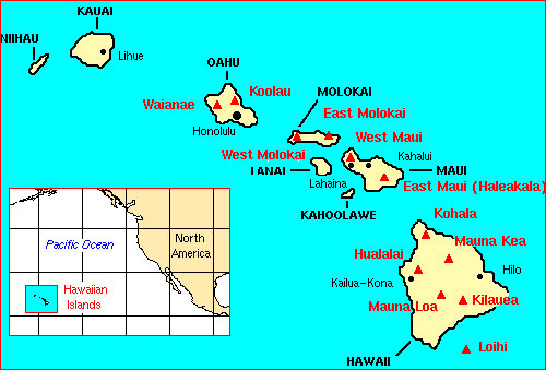
Main Hawaiian Islands
The Hawaiian Archipelago is distributed approximately 1,296 nautical miles (2,960 km) in the north central Pacific Ocean. It consists of two regions: eight populated large islands, referred to as the Main Hawaiian Islands (MHI), and 124 mostly uninhabited small islands, atolls, reefs, and submerged banks to the northwest of the MHI, referred to as the Northwestern Hawaiian Islands (NWHI).
The eight Main Hawaiian Islands, listed from East to West are: Hawaii, Maui, Kahoolawe, Lanai, Molokai, Oahu, Kauai, and Niihau. All except Kahoolawe are inhabited.
The MHI are high volcanic islands with non-structural reef communities, fringing reefs, and two barrier reefs. With few exceptions, the near-shore coral reefs range from fair to excellent condition but are threatened by continued population growth, overexploitation of many target food fishes and invertebrates, urbanization, runoff, and development. Attractive marine aquarium trade species have been heavily exploited. Introduced aquatic alien species are threats because they may out-compete endemic species.
Greater than 60 percent of coral reefs in U.S. waters are found in the Hawaiian Archipelago. These marine ecosystems are not only ecologically important but also provide hundreds of millions of dollars annually to Hawaii’s economy.
Highlights
OCM Coastal Impact Stories: Coral Reef Conservation Program in Hawaii.
Coral Reef Condition: A Status Report for the Hawaiian Archipelago (2018)
National Coral Reef Monitoring Program Socioeconomic Monitoring Component Summary Findings for Hawaii (2015)
Publications
Fish, invertebrate and benthic surveys along the West coast of Hawaii from 2003-03-01 to 2017-03-01
Dataset is hosted by NOAA National Center for Environmental Information, and includes the following datasets:
- Fish and invertebrate surveys: At each permanent monitoring site (26 at present), fishes and urchins are recorded on 4 fixed 25m transects.
- Benthic surveys: Benthic cover is assessed at all monitoring sites, typically during the spring every three years (or annually following an anticipated substantial change in benthic cover). Benthic images (0.30 m2) are taken at each meter along four 25 m transects at each site.
- Coral bleaching/ health surveys: In response to extensive coral bleaching in West Hawaii during the spring/summer of 2015, coral bleaching/ health surveys were conducted at 8 permanent monitoring sites from 9 October to 13 November 2015 using methods described in Couch et al. 2014.
Acoustic Characterization of Mesophotic Coral Reef Ecosystems of West Hawai'i. NOAA Technical Memorandum NMFS-PIFSC-61.
Reef Monitoring Summary Report for Ahihi-Kina'u Natural Area Reserve, Polanui, and Wailuku, Maui and Kaho'olawe, Hawai'i
Hawaii's Coral Reef Management Priorities
Hawaii Capacity Assessment Report and Coral Reef Conservation Time Line
Hawaii Coral Bleaching Recovery Plan
Assessing the Resilience of Leeward Maui Reefs to Help Design a Resilient Managed Area Network
Relative resilience potential and bleaching severity in the West Hawaii Habitat Focus Area in 2015. NOAA Technical Memorandum CRCP 26.
Monitoring Hawaii’s Marine Protected Areas: Examining Spatial and Temporal Trends Using a Seascape Approach. NOAA Technical Memorandum NOS NCCOS 117.
Fish Habitat Utilization Patterns and Evaluation of the Efficacy of Marine Protected Areas in Hawaii: Integration of NOAA Digital Benthic Habitat Mapping and Coral Reef Ecological Studies NOAA Technical Memorandum NOS NCCOS 23
Prediction of Mesophotic Coral Distributions in the Au'au Channel, Hawaii. NOAA Technical Memorandum NOS NCCOS 149
Catalog of coral reef fish life history specimens for the Hawaiian Islands Pacific Islands Fisheries Science Center Administrative Report H-11-05
National Coral Reef Monitoring Program Socioeconomic Monitoring Component Summary Findings for Hawaii (2015)
Economic Valuation of the Coral Reefs of Hawaii
Economic Analysis of Marine Managed Areas in the Main Hawaiian Islands
Report on the Status of Marine Protected Areas in Coral Reef Ecosystems of the United States. Volume 1: Marine Protected Areas Managed by U.S. States,Territories, and Commonwealths. NOAA Technical Memorandum CRCP 2 February 2007
Status Reports
Coral Reef Condition: A Status Report for the Hawaiian Archipelago (2018)
State of the Reefs Reports (SOTR)
The State of Coral Reef Ecosystems of the United States and Pacific Freely Associated States: 2008.
The State of Coral Reef Ecosystems of the United States and Pacific Freely Associated States: 2005.
The State of Coral Reef Ecosystems of the United States and Pacific Freely Associated States: 2002.
Local Action Strategy
Hawaii Local Action Strategy Factsheet
FLASH Strategic Plan: Fisheries Local Action Strategy in Hawai'i (FLASH)
Hawai'i's Local Action Strategy to Address Land-Based Pollution Threats to Coral Reefs
Hawaii's local action strategy to address recreational impacts to reefs
Hawaii's Climate Change and Marine Disease Local Action Strategy April 2007
Management Activities
Maui Nui Conservation Action Plans
Summary of Support for Implementation of Priority Strategies at DLNR Conservation Action Plan Sites
Hawaii Coral Bleaching Recovery Plan
Kahekili, Maui, Hawaii, Conservation Action Plan
Kaho‘olawe Island Reserve: 'Ili O Kealaikahiki Conservation Action Plan
Kīholo Conservation Action Plan draft report
Molokini Shoal Marine Life Conservation District Conservation Action Plan
South Kohala Conservation Action Plan
Wahikuli-Honokōwai Coastal Conservation Action Plan
Wahikuli-Honokōwai Wildfire Mitigation Plan: Reducing wildfire hazards and impacts in the Wahikuli-Honokōwai watersheds
Watershed Management Plans
Wai'ula'ula Watershed Plan
Honokwai
and Wahikuli, West Maui, Hawaii, Watershed Management Plan
Kahana, Honokahua & Honolua Watershed Characterization Report Vol.1 (draft)
Metadata, Data and Publications Search in CoRIS
Search the CoRIS Geoportal for Main Hawaiian Islands metadata, data and publications
ReefBase Coral Bleaching Reports -
Select "U.S. Pacific Islands" in the Region window and "Main Hawaii Islands" in the Country window.
Near-real-time Data
Coral Reef Watch Satellite Monitoring
Coral Reef Watch - Hawaiian Islands Virtual Stations
The Global Temperature-Salinity Profile Program
NOAA/National Weather Service - Data from Hawaii
USGS Water Resources - Data for Hawaii
NOAA CO-OPS - Tide Data
NOAA Tidal Predictions - Hawaii
National Data Buoy Center
Ala Wai Ocean Acidification Monitoring Buoy
Kilo Nalu Ocean Acidification Monitoring Buoy
Kaneohe Ocean Acidification Monitoring Buoy
CRIMP2 Ocean Acidification Monitoring Buoy
CRIMP Ocean Acidification Monitoring Buoy
Other Data & Information
Shallow-water Benthic Habitats of the Main Hawaiian Islands
Ocean Biogeographic Information System (OBIS)
Benthic Habitats and Offshore Geological Resources of Kaloko-Honokōhau National Historical Park, Hawai‘i
Hawai‘i Coral Reef Assessment and Monitoring Program
Hawaiian Reef Algae
Fish Species Observed in the Hawaii Exclusive Economic Zone from the 1750s through 2003
Hawaii Environmental Sensitivity Index (ESI) Atlas
Coastal Change Analysis Program (C-CAP) - Hawaii Land cover Data
Pacific Islands Benthic Habitat Mapping Center - Main Hawaiian Islands
USGS Projected Flood Extent for Hawaii
Education and Outreach
Coral Reef Outreach network
Hawaii Coral Reefs
Hawaii Coral Reef Initiative Research Program
The Coral Reef Alliance
The Nature Conservancy in Hawaii
Waikiki Aquarium
Marine Life Photography - Marine life identification guide for Hawaii & beyond
New Mapping Techniques Help Assess the Health of Hawaii’s Coral Reefs
Coral and Live Rock Laws of Hawaii
Hawaii Sharks
Marine Protected Areas/Marine Managed Areas
Marine Protected Areas of the United States Home Page
The Marine Protected Areas Inventory
Federal MPA Legislation
Marine Federal Areas Fact Sheet
Executive order 13158: Marine Protected Areas
Ahihi-Kinau Natural Area Reserve
Barbers Point
Hakalau to Onomea Bay
Hanalei-Kilauea Point
Hanamaulu Bay, Ahukini Recreational Pier
Hanauma Bay - Marine Life Conservation District
Hawaiian Islands Humpback Whale National Marine Sanctuary
Hilo Bay, Wailoa River, Wailuku River
Ilio Point to Panalaia Point
Ka Lae
Kaena Point to Makua
Kahoolawe Island Reserve
Kahului Harbor
Kailua Bay
Kalaupapa National Historical Park
Kalohi/Pailolo Channels
Kaloko-Honokohau National Historical Park
Kaneohe Bay
Kaunakakai Harbor, Moloka'i
Kaupo to Kaapahu Bay
Kawaihae Harbor
Kealakekua Bay - Marine Life Conservation District
Keauhou Bay
Kiholo Bay
Kilauea Point National Wildlife Refuge
Kona Coast
Lapakahi - Marine Life Conservation District
Leleiwi Point to Kaloli Point
Makahuena Point to S. Kawai Point
Makapuu Point
Makawana Point to Pauwela Point
Manele Harbor
Manele-Hulopo'e - Marine Life Conservation District
Maunalua Bay
Coconut Island - Hawaii Marine Laboratory Refuge
Molokini Shoal - Marine Life Conservation District
Nawiliwili Harbor
Niihau
Old Kona Airport - Marine Life Conservation District
Palemano Point to Alika
Pearl Harbor National Wildlife Refuge
Penguin Bank, pinnacle
Penguin Bank, Third Finger
Port Allen
Puako Bay, Puako Reef
Pupukea - Marine Life Conservation District
Puukohola Heiau National Historic Site
Waialea Bay
Waikiki - Marine Life Conservation District
Waikiki-Diamond Head
Waimea Bay, Waimea Recreational Pier
West Hawaii Regional Fisheries Management Area