noaa.gov

Guam

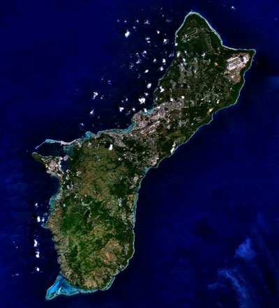
Guam, a United.States. unincorporated territory, is the southernmost island in the Mariana Archipelago. It is located in the western Pacific approximately 3,700 miles west-southwest of Honolulu, Hawaii; 1,500 miles east of Manila; and 1,500 miles south-southeast of Tokyo, Japan. It is the largest island in Micronesia, with a land mass of 216 mi2 and a maximum elevation of approximately 405 meters. It is also the most heavily populated island in Micronesia with a population of about 168,000 people (July 2018 est). The northern portion of the island is relatively flat and consists primarily of uplifted limestone. The southern half of the island is primarily volcanic, with more topographic relief and large areas of highly erodible soils. This topography creates a number of watersheds throughout the southern areas which are drained by 96 rivers.

The condition of Guam’s coral reefs (including fringing reefs, patch reefs, submerged reefs, offshore banks, and barrier reefs) varies considerably, depending on a variety of factors including geology, human population density, degree of coastal development, levels and types of marine resource uses, oceanic circulation patterns, and frequency of natural disturbances (e.g., storms and earthquakes). Many of Guam’s reefs have declined in health over the past 40 years. However, in the past, Guam’s coral reefs have recovered after drastic declines. For example, an outbreak of the crown-of-thorns seastar in the early 1970s reduced coral cover in some areas from 50 to 60% to less than 1%. Twelve years later, greater than 60% live coral cover was recorded for these areas. A more distressing indicator of the condition of Guam’s coral reefs is the marked decrease in rates of coral recruitment.

Reefs unaffected by sediment, nutrient loading, and freshwater runoff in the northern part of the island and between river outflows, have relatively healthy coral communities. The reefs have not suffered the large scale bleaching events and coral diseases seen in other parts of the world. Unfortunately, some reefs have been damaged by land-based sources of pollution and heavy fishing pressure.

Guam satellite map

Guam satellite map

Highlights

OCM Coastal Impact Stories: Coral Reef Conservation Program in Guam

Coral Reef Condition: A Status Report for Guam (2018)

National Coral Reef Monitoring Program Socioeconomic Monitoring Component Summary Findings for Guam (2016)

Publications

Successive bleaching events cause mass coral mortality in Guam, Micronesia (2019)

Guam's Coral Reef Management Priorities (2010)

Guam Capacity Assessment Report and Coral Reef Conservation Time line

Guam Coral Bleaching Response Plan (April 2017)

Design and Parameterization of a Coral Reef Ecosystem Model for Guam

National Coral Reef Monitoring Program Socioeconomic Monitoring Component Summary Findings for Guam (2016)

Gap Analysis of Marine Ecosystem Data for the Dept. of Interior – National Park Service Inventory and Monitoring Program (Sept. 2011)

Mapping of Benthic Habitats for U.S. Pacific Territories: American Samoa, Guam, and The Commonwealth of the Northern Mariana Islands

The economic value of Guam's coral reef

Status of coral reef fish assemblages and benthic condition around Guam: A report based on underwater visual surveys in Guam and the Mariana Archipelago, April-June 2011 U.S. Dept. of Commerce, NOAA Technical Memorandum NOAA-TM-NMFS-PIFSC-33, 22

The Micronesia Challenge

Report on the Status of Marine Protected Areas in Coral Reef Ecosystems of the United States.
Volume 1: Marine Protected Areas Managed by U.S. States,Territories, and Commonwealths. NOAA Technical Memorandum CRCP 2 February 2007

Guam’s 5-Year Coral Reef Initiative Program

Potential larval sources, destinations, and self-seeding in the Mariana Archipelago documented using ocean drifters (Journal of Oceanography, 2014)

Field Identification Guide to the Threatened Corals of the U.S. Pacific Islands

Acropora retusa from Guam. Photo copyright David Burdick

Acropora retusa from Guam. Photo copyright David Burdick.

Status Reports

Coral Reef Condition: A Status Report for Guam (2018)

State of The Reefs Report (SOTR)

The State of Coral Reef Ecosystems of the United States and Pacific Freely Associated States: 2008.

The State of Coral Reef Ecosystems of the United States and Pacific Freely Associated States: 2005.

The State of Coral Reef Ecosystems of the United States and Pacific Freely Associated States: 2002.

Watershed Management Plans

Piti-Asan watershed management plan

A GIS-based watershed management plan for the Piti-Asan watersheds

Draft Conservation Plan for the Piti Bomb Holes Marine Preserve and Adjacent Watershed

Metadata, Data and Publications Search in CoRIS

Search the CoRIS Geoportal for Guam metadata, data and publications

ReefBase Coral Bleaching Reports -

Select "Micronesia" in the Region window and "Guam" in the Country window

Near-real-time Data

Coral Reef Watch Satellite Monitoring

Coral Reef Watch - Mariana Islands and Guam

The Global Temperature-Salinity Profile Program

USGS Water Resources - Data for Guam

NOAA CO-OPS Tide data

NOAA Tide Predictions - Guam

Other Data

Maps of Guam

Shallow-water Benthic Habitat Maps of American Samoa, Guam, and the Commonwealth of the Northern Mariana Islands (CNMI)

Guam Coastal Atlas - The atlas provides benthic habitat maps and geospatial data for the nearshore waters of Guam.

Natural Resources Atlas of Southern Guam

Digital Atlas of Northern Guam

Coastal Guam Aerial Imagery Project

Pacific Islands Benthic Habitat Mapping Center - Guam

Guam and the Northern Mariana Islands Environmental Sensitivity Index (ESI) Atlas

Government of Guam's Map Viewer-

USGS Projected Flood Extent for Guam

Coastal Change Analysis Program (C-CAP) Landcover Data - Guam

Pacific Islands Ocean Observing System Data Portal - Guam

Education and Outreach

University of Guam Marine Laboratory

Guam - CIA World Factbook

The Micronesia Challenge

Marine Protected Areas/Marine Managed Areas

Marine Protected Areas of the United States Home Page

The Marine Protected Areas Inventory

Federal MPA Legislation

Marine Federal Areas Fact Sheet

Executive order 13158: Marine Protected Areas

Achang Reef Flat Reserve

Guam information including list of MPAs

Guam National Wildlife Refuge

Haputo Ecological Reserve Area

Orote Peninsula Ecological Reserve Area

Piti Bomb Holes Marine Preserve

Research in Guam’s Marine Protected Areas: Piti Bomb Holes Reserve

Tumon Bay Marine Preserve

War-in-the-Pacific National Historical Park