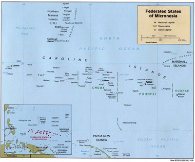
Federated States of Micronesia
The Federated States of Micronesia (FSM) is part of the Freely Associated States, which also includes the Republic of the Marshall Islands and the Republic of Palau. With the dissolution of the Trust Territory of the Pacific (TTPI), a United Nations mandate managed by the United States, and comprised of those islands that had been Japanese colonies until the end of WW II, Micronesia emerged as a separate political entity. Palau and the Northern Mariana Islands negotiated independent terms with the United States. The three former TTPI districts of Yap, Chuuk (formerly Truk) and Pohnpei united to form the new Federated States of Micronesia. A portion of the Pohnpei district was separated to make the state of Kosrae. Consequently the FSM has four states, from west to east: Yap, Chuuk, Pohnpei, and Kosrae. Each state supports population centers on high volcanic islands.
Yap State consists of four volcanic islands plus 19 inhabited outer islands and atolls, with a total land area of 46 square miles. Yap State can be divided into two distinct spheres: "Yap Proper" and the "Outer Islands." Yap Proper is a cluster of relatively high islands with volcanic and continental rock, surrounded by a fairly wide reef platform. The Outer Islands are coral islands and atolls scattered over a wide area, with relatively low populations.
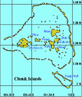
Chuuk State comprises the volcanic islands in the Chuuk Lagoon and some 24 outer-island atolls--in all, some 290 islands. Chuuk is the most populous of the FSM states with a land area of 49 square miles. Chuuk lagoon is the largest in the FSM. It is a world famous spot for scuba divers, with a sunken WWII Japanese fleet to explore on the floor of the lagoon. Chuuk was formerly known as “Truk.”
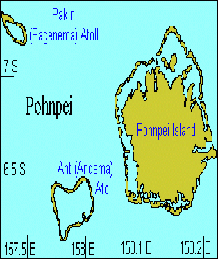
Pohnpei State is the national capital of the FSM. It is made up of one large volcanic island and six inhabited atolls, with most of its 133 square miles on Pohnpei Island. Pohnpei Island has a well developed barrier reef and associated lagoon.
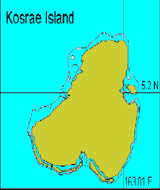
Kosrae State is one volcanic island of 43 square miles, surrounded by a fringing reef. Its reefs and mangrove forests are considered to be among the healthiest in Micronesia. However, recent coastal development and land use patterns place the coral reefs at risk.
Each island group has its own language, culture, local government, and traditional system for managing its marine resources. The FSM has both high islands and low atolls. The islanders have strong cultural and economic dependence on coral reefs and marine resources.
Reefs in the FSM are generally in good shape, but there are water quality concerns in areas where there is ongoing coastal development and agriculture. Some degradation of reef ecosystems has already occurred in the more populated areas. Several large development projects, such as construction of an airport and a deep draft harbor, have had significant impacts on mangrove forests and local reefs. Reefs located near population centers, within harbors, and close to shipping lanes have had the largest impacts from fishing and ship groundings. Over-fishing and other harmful fishing practices are also causes of concern.
Publications
Field Guide to the Corals of the Federated States of Micronesia
Coral Reefs Case Study: Federated States of Micronesia
FSM National Biodiversity Strategy and Action Plan
A Blueprint for Conserving the Biodiversity of the Federated States of Micronesia
A Rapid Ecological Assessment of the Coral, Fish and Seagrasses of Pohnpei, Ahnd and Pakin, Federated States of Micronesia – Findings and Recommendations
A threats and needs assessment of coastal marine areas in the states of Kosrae, Chuuk and Yap, Federated States of Micronesia
Final Progress Report: A Field and Household Assessment of Non-commercial Fishing, Per Capita Consumption and Trade Patterns for Coral Reef Fishery Management Improvement in Pohnpei, Micronesia
Pacific Islands Water Science Center Publications - Federated States of Micronesia
State of The Reefs Report (SOTR)
The State of Coral Reef Ecosystems of the United States and Pacific Freely Associated States: 2008.
The State of Coral Reef Ecosystems of the United States and Pacific Freely Associated States: 2005.
The State of Coral Reef Ecosystems of the United States and Pacific Freely Associated States: 2002.
Conservation Action Plans
Awane Marine Park Conservation Action Plan
Nett District Conservation Action Plan
Tamil Municipal Marine Management Plan
Yap Manta Ray Sanctuary Conservation Action Plan
Metadata, Data and Publications Search in CoRIS
Search the CoRIS Geoportal for Federated States of Micronesia metadata, data and publications.
ReefBase Coral Bleaching Reports
Select "Micronesia" in the Region window and "Federated States of Micronesia" in the Country window
Real Time and Near-Real Time Monitoring Data
Coral Reef Watch Satellite Monitoring
Coral Reef Watch - Eastern FSM Virtual Stations
The Global Temperature-Salinity Profile Program
FSM Weather Information
National Weather Service
NOAA Tidal Predictions - Federated States of Micronesia
Pohnpei Continuous GPS station
National Data Buoy Center - Western Pacific Recent Marine Data
Other Data
Seagrasses: Pohnpei Island and Ahnd Atoll Marine Assessment
GIS Map of Mosaiced LandSat 7 ETM+ Satellite Imagery of the Federated States of Micronesia
Key Documents
Executive orders, Secretarial Orders, and Congressional Acts
Government of the Federated States of Micronesia
Education and Outreach
FSM Visitors Board
Conservation Society of Pohnpei
Federated States of Micronesia - World Factbook
U.S. Department of the Interior / Office of Insular Affairs
U.S. State Department
Jane’s Federated States of Micronesia
Marine Protected Areas/Marine Managed Areas
Marine Protected Areas of the United States Home Page
The Marine Protected Areas Inventory
Federal MPA Legislation
Marine Federal Areas Fact Sheet
Executive order 13158: Marine Protected Areas