Puerto Rico
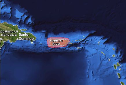
Puerto Rico is located in the north central Caribbean between the U.S. Virgin Islands to the east and the island of Hispaniola to the west. It is an archipelago comprised of the main island, the islands of Mona, Monito, and Desecheo in the Mona Passage, Caja de Muertos Island on the south coast, Vieques Island, Culebra Island, and a series of smaller islets, the "Cordillera de Fajardo."
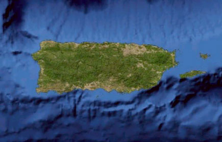
The land area of Puerto Rico is comprised of coastal lowlands, a mountainous interior, and a karst area in the north. The central mountain chain is oriented east to west, with most of the major rivers flowing toward the northern shore. Other major mountain ranges are located in the northeastern, southeastern and northwestern regions. The island has no natural lakes. The climate is tropical marine with average coastal temperatures of about 26 °C (80°F), slightly cooler in the interior.
Puerto Rico is mostly surrounded by deep water. The Mona Passage, between Puerto Rico and Hispaniola, is more than 1,000 meters (0.6 miles) deep. The Puerto Rico Trench (the deepest part of the Atlantic Ocean), off the northern coast, is 8,500 meters (5.3 miles) deep, and from the southern coast, the ocean bottom descends 5,000 meters (3 miles) to the Venezuelan Basin
Puerto Rico has a diversity of unique terrestrial and marine ecosystems including coastal mangrove forests, seagrass beds, coral reefs, tropical rain forests, tropical dry forests, and coastal plains. The archipelago harbors a diverse flora and fauna with a high level of endemism. The island has a linear coastline of 620 km (385 mi), surrounded by over 5,000 km2 (1930 mi2) of shallow coral reef ecosystems. High population density and land uses have resulted in harmful impacts to the coral reefs, by sedimentation, eutrophication, and pollution, further compounded by algal growth and overfishing. Coral bleaching, diseases, invasive species, and physical damage have also contributed to the declining health of the reefs.
Highlights
OCM Coastal Impact Stories: Coral Reef Conservation Program in Puerto Rico
National Coral Reef Monitoring Program Socioeconomic Monitoring Component Summary Findings for Puerto Rico (2015)
Publications
Puerto Rico's Coral Reef Management Priorities (2010)
Puerto Rico Capacity Assessment Report and Coral Reef Conservation Timeline
Coral reef ecosystems of Reserva Natural La Parguera (Puerto Rico): Spatial and temporal patterns in fish and benthic communities (2001-2007). NOAA Technical Memorandum NOS NCCOS 107
A Baseline Assessment of the Ecological Resources of Jobos Bay, Puerto Rico
An Ecological Characterization of the Marine Resources of Vieques, Puerto Rico. Part I: Historical Data Synthesis
An Ecological Characterization of Vieques, Puerto Rico Part II: Field Studies of Habitats, Nutrients, Contaminants, Fish, and Benthic Communities
Biogeographic Characterization of Essential Fish Habitats Affected by Human Activities in the Coastal Zone of Puerto Rico. NOAA Technical Memorandum NOS NCCOS 115
Reefs at Risk Revisited
USGS Water Resources of the Caribbean
National Coral Reef Monitoring Program Socioeconomic Monitoring Component Summary Findings for Puerto Rico (2015)
Report on the Status of Marine Protected Areas in Coral Reef Ecosystems of the United States. Volume 1: Marine Protected Areas Managed by U.S. States,Territories, and Commonwealths. NOAA Technical Memorandum CRCP 2 February 2007
Chapter 16 - Status Of Coral Reefs in the U.S. Caribbean and Gulf of Mexico: Florida, Flower Garden Banks, Puerto Rico, U.S. Virgin Islands, Navassa. In Status of Coral Reefs of the World: 2008. Edited by Clive Wilkinson.
Socioeconomic monitoring guidelines for coastal managers in the Caribbean: Socmon Caribbean
Puertorican Reefs: Research synthesis, present threats and management perspectives
Investigating Coral Reef Ecosystems in Support of NASA’s Earth Science Program
Puerto Rico Water Resources and Environmental Research Institute
State of the Reefs Reports (SOTR)
The State of Coral Reef Ecosystems of the United States and Pacific Freely Associated States: 2008.
The State of Coral Reef Ecosystems of the United States and Pacific Freely Associated States: 2005.
The State of Coral Reef Ecosystems of the United States and Pacific Freely Associated States: 2002.
Local Action Strategy
Puerto Rico Local Action Strategies for Coral Reef Conservation 2011-2015
Puerto Rico Local Action Strategy Factsheet
Management Activities
DRNA: Programa de Conservación y Manejo de Arrecifes de Coral
The Cabo Rojo Conservation Plan
Plan de manejo de la Reserva Natural Canal de Luis Pena, Culebra, Puerto Rico
Plan de Manejo de la Reserva Marina Tres Palmas, Rincon, Puerto Rico
Puerto Rico's rapid response contingency plan for coral bleaching, disease outbreaks and other ecological surprises
Plan de manejo estrategico de los arescifes de coral de Puerto Rico
Plan de ordenamiento para el uso de embarcaciones y el establecimiento de boyas de amarre reservas naturales: La Parguera, Bosque Estatal de Guanica, Caja de Muertos, Arrecifes de la Cordillera y Canal Luis Pena
Plan de comunicacion ambiental para la conservacion de los arrecifes de coral en Puerto Rico
Culebra Pilot Community Adaption Plan to Climate Change (Plan Piloto Comunitario de Adaptación al Cambio Climático Municipio de Culebra)
Watershed Management Plans
Guanica Bay Watershed Management Plan - A Pilot Project for Watershed Planning in Puerto Rico
Northeast Ecological Corridor Natural Reserve Integrated Watershed Management Plan: Final Integrated Watershed Management Plan, March 2017
Culebra Community Watershed Action Plan for Water Quality and Coral Reefs
Cabo Rojo Community Watershed Action Plan for Water Quality and Coral Reefs
Metadata, Data and Publications Search in CoRIS
Search the CoRIS Geoportal for Puerto Rico metadata, data and publications.
ReefBase Coral Bleaching Reports
Select "U.S. Caribbean" in the region window and "Puerto Rico" in the Country window.
Near-real-time Data
Coral Reef Watch Satellite Monitoring
Coral Reef Watch - Puerto Rico Virtual Stations
The Global Temperature-Salinity Profile Program
NOAA/National Weather Service - Data from Puerto Rico
NOAA CO-OPS - Tide Data
- 9753216 Fajardo, PR
- 9759938 Mona Island, PR
- 9755371 San Juan, PR
- 9759110 Magueyes Island, PR
- 9752619 Isabel Segunda, Vieques Island, PR
- 9754228 Yabucoa Harbor, PR
- 9759394 Mayaguez, PR
- 9752695 Esperanza, Vieques Island, PR
NOAA Tide Predictions - Puerto Rico
USGS Water Resources of the Caribbean: Real-Time Streamflow, Lake-Level and Rainfall Data for Puerto Rico
USGS current water data for Puerto Rico
Real-time tracking of changes to rivers and streams within Puerto Rico
WaterWatch - Current Streamflow Conditions
Real-time tracking of flood conditions within Puerto Rico
Drought Watch
Real-time and historical earthquake information within Puerto Rico
Earthquake Activity
La Parguera Ocean Acidification Monitoring Buoy
Other Data
Benthic Habitat Mapping of Puerto Rico and the U.S. Virgin Islands
Benthic Habitat Mapping Data - An Ecological Characterization of the Marine Resources of Vieques, Puerto Rico
Vieques BIOMapper - an interactive web tool to view maps & data
Jobos Bay BIOMapper
- an interactive web tool to view maps & data
GEOID99 Data for Puerto Rico and the U.S. Virgin Islands: PC format
Puerto Rico and the Virgin Islands Earthquake Information
Puerto Rico Environmental Sensitivity Index (ESI) Files
Historical Climate Summaries for Puerto Rico and the U.S. Virgin Islands
Seafloor Characterization of the U.S. Caribbean
Puerto Rico Environmental Sensitivity Index (ESI) Files
USGS Projected Flood Extent for Puerto Rico
Education and Outreach
Caribbean Coral Reef Institute
Department of Marine Sciences of the University of Puerto Rico, Mayagüez
http://cima.uprm.edu/magueyes.html
Puerto Rico- Source: 2007 CIA WORLD FACTBOOK and the Library of Congress Country Studies
Ocean and Coastal Management in Puerto Rico
Jobos NERR - Facebook page
University of Puerto Rico Sea Grant College Program
Marine Protected Areas/Marine Managed Areas
Marine Protected Areas of the United States Home Page
The Marine Protected Areas Inventory
Federal MPA Legislation
Marine Federal Areas Fact Sheet
Executive order 13158: Marine Protected Areas
Marine Protected Areas of the United States: Puerto Rico
Arrecifes de tourmaline Natural Reserve
Arrecifes de Guayama Natural Reserve
Arrecifes de la Cordillera Natural Reserve
Bahías Bioluminiscentes de Vieques Natural Reserve
Bosque Estatal de AguirreBosque Estatal de Ceiba Natural Reserve
Bosque Estatal de Guánica Natural Reserve
Bosque Estatal de Piñones Natural Reserve
Bosque Natural de Boquerón Natural Reserve
Cabezas de San Juan Natural Reserve
Cabo Rojo National Wildlife Refuge
Caja de Muertos Natural Reserve
Canal Luis Pena Natural Reserve
Cabezas de San Juan Natural Reserve
Cueva del Indio Natural Reserve
Culebra National Wildlife Refuge
Desecheo National Wildlife Refuge
El Pantano, Bosque de Pterocarpus y Lagunas Mandry y Santa Teresa Natural Reserve
Hacienda La Esperanza Natural Reserve
Isla de Desecheo Marine Reserve
Isla de Mona Natural Reserve
Jobos Bay National Estuarine Research Reserve
La Parguera Natural Reserve
Laguna Cartagena National Wildlife Refuge
Laguna Joyuda Natural Reserve
Pantano Cibuco Natural Reserve
Punta Guaniquilla Natural Reserve
Punta Yeguas Natural Reserve
Red Hind Spawning Aggregation Areas West of Puerto Rico - Abrir La Sierra
Red Hind Spawning Aggregation Areas West of Puerto Rico - Bajo de Cico
Red Hind Spawning Aggregation Areas West of Puerto Rico - Tourmaline Bank
Rio Espíritu Santo Natural Reserve Natural
Tres Palmas de Rincon Marine Reserve
Vieques National Wildlife Refuge
Electronic Code of Federal Regulations: Fisheries of the Caribbean, Gulf, and South Atlantic