U. S. Virgin Islands
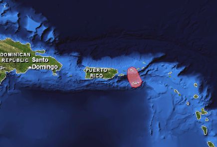
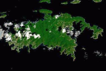
The U.S. Virgin Islands (USVI), a territory of the United States, is a group of islands in the Caribbean. The islands are geographically part of the Virgin Islands archipelago and are located in the Lesser Antilles. The USVI consists of three large main islands east of Puerto Rico and several smaller islands. St. Croix is the largest island, St. Thomas is the second largest, and St. John is the third largest. The total land area of the USVI is 346 km2 (134 mi2).
The biologically rich coral reef ecosystems in the USVI consist of a mosaic of benthic habitats, principally hard coral and other hard bottom areas, seagrass meadows, and mangrove forests that are home to a great diversity of organisms. These coral reef ecosystems provide, inter alia, shoreline protection and support valuable socio- economic activities. Coral reefs in the USVI and reefs elsewhere in the Caribbean face similar environmental stresses which include climate change, diseases, storms, coastal development and runoff, coastal pollution, tourism and recreation, fishing, and groundings.
Highlights
Publications
USVI's Coral Reef Management Priorities (2010)
US Virgin Islands Capacity Assessment Report and Coral Reef Conservation Timeline
Benthic Habitat Mapping
St. Thomas East End Reserves (STEER)
Fish Assemblage and Benthic Habitats of Buck Island Reef National Monument (St. Croix, U.S. Virgin Islands) and the Surrounding Seascapes: A Characterization of Spatial and Temporal Patterns
Survey and impact assessment of derelict fish traps in St. Thomas and St. John, U.S. Virgin Islands. NOAA Technical Memorandum NOS NCCOS 147
National Coral Reef Monitoring Program Socioeconomic Monitoring Component Summary Findings for USVI (2017)
Gap Analysis of Marine Ecosystem Data for the Dept. of Interior – National Park Service Inventory and Monitoring Program (Sept. 2011)
Report on the Status of Marine Protected Areas in Coral Reef Ecosystems of the United States. Volume 1: Marine Protected Areas Managed by U.S. States,Territories, and Commonwealths. NOAA Technical Memorandum CRCP 2 February 2007
Socioeconomic monitoring guidelines for coastal managers in the Caribbean: Socmon Caribbean
USGS Water Resources of the Caribbean
State of the Reefs Reports (SOTR)
The State of Coral Reef Ecosystems of the United States and Pacific Freely Associated States: 2008.
The State of Coral Reef Ecosystems of the United States and Pacific Freely Associated States: 2005.
The State of Coral Reef Ecosystems of the United States and Pacific Freely Associated States: 2002.
Local Action Strategy
U.S. Virgin Islands Local Action Strategy Factsheet
Fisheries Local Action Strategy Projects in the US Virgin Islands: Progress and Direction
An Analysis of Issues Affecting the Management of Coral Reefs and the Associated Capacity Building Needs in the United States Virgin Islands
Watershed Management Plans
Coral Bay watershed management plan : a pilot project for watershed planning in the USVI
Fish Bay management plan for Fish Bay watershed, St. John, United States Virgin Islands Department of Planning & Natural Resources 2001
St. Croix East End Watersheds Management Plan - (November 2011)
2013 St. Thomas East End Reserves Watershed Management Plan
2013 STEER Watershed Existing Conditions Report
Metadata, Data and Publications Search in CoRIS
Search the CoRIS Geoportal for Virgin Islands metadata, data and publications
Reef Base Coral Bleaching Reports - Select "U.S. Caribbean" in the region window and "Virgin Islands (U.S.)" in the Country window.
Near-real-time Data
Coral Reef Watch Satellite Monitoring
Coral Reef Watch - Virgin Islands Virtual Stations
The Global Temperature-Salinity Profile Program
NOAA/National Weather Service - Data from U.S. Virgin Islands
USGS Water Resources - Data for U.S. Virgin Islands
NOAA CO-OPS - Tide Data
NOAA Tide Predictions - Lesser Antilles & Virgin Islands
Other data
Characterizing Participation in Non-Commercial Fishing and other Shore-based Recreational Activities on St. Croix, U.S. Virgin Islands
Patterns of shore-based fishing and recreation on St. Croix, USVI
STEER Coastal Use Mapping Project
St. John BIOMapper - an interactive web tool to view maps & data
An Ecological Characterization of the Salt River Bay National Historical Park and Ecological Preserve, U.S. Virgin Islands
Buck Island Reef National Monument, St. Croix, U.S. Virgin Islands
Seafloor Characterization of the U.S. Caribbean
USGS Coastal & Marine Geology InfoBank Regions (Virgin Islands) Data & Metadata
Historical Climate Summaries for Puerto Rico and the U.S. Virgin Islands
GEOID99 Data for Puerto Rico and the U.S. Virgin Islands: PC format
Anaglyph with Landsat Virgin Islands, Caribbean
Puerto Rico and the Virgin Islands Earthquake Information
U.S. Virgin Islands Environmental Sensitivity Index (ESI) Files
USGS Projected Flood Extent for USVI
Education and Outreach
Marine Outreach and Education US Virgin Islands Style (MOES-VI): Strategizing for Improved Outreach, Education and Communication Pertaining to USVI Marine and Fisheries Management and Conservation
Evaluation of Marine Outreach and Education USVI Style Initiative: Improving Fishing Community Awareness and Compliance
Virgin Islands National Park
Virgin Islands - Source: 2006 CIA WORLD FACTBOOK and the Library of Congress Country Studies
Marine Protected Areas/Marine Managed Areas
Electronic Code of Federal Regulations: Fisheries of the Caribbean, Gulf, and South Atlantic
Marine Protected Areas of the United States Home Page
The Marine Protected Areas Inventory
Federal MPA Legislation
Marine Federal Areas Fact Sheet
Executive order 13158: Marine Protected Areas
Areas of particular Concern (APC)
Island Resources Foundation, 2002. Resource Description Report.
University of the Virgin Islands and Department of Planning and Natural Resources. USVI, 14 August, 2002.
Botany Bay APC
Buck Island National Wildlife Refuge
Buck Island Reef National Monument
Cas Cay - Mangrove lagoon Marine Reserve and Wildlife Sanctuary
Cas Cay - Mangrove lagoon Marine Reserve and Wildlife Sanctuary
Chocolate Hole-Great Cruz bay APC
Christiansted Waterfront APC
Compass Point Pond Marine Reserve and Wildlife Sanctuary
Coral Bay APC
Enighed Pond-Cruz Bay APC
Establishment of the Virgin Islands Coral Reef National Monument
Frank Bay Wildlife and Marine Sanctuary
Frederiksted Waterfront APC
Great Pond and Great Pond Bay APC
Green Cay National Wildlife Refuge
Magens Bay & Watershed APC
Mandahl Bay APC Mangrove Lagoon-Benner
Mangrove Lagoon-Benner Bay APC
MPA Global. A Database of the world’s marine protected areas: U.S. Virgin Islands
Mutton Snapper Spawning Aggregation Area
Salt River Bay National Park and Ecological Reserve
Salt River Bay & Watershed
Salt River Bay Marine Reserve and Wildlife Sanctuary Selective Bibliography: Salt River Canyon Region, St. Croix USVI
Sandy Point National Wildlife Refuge
Sandy Point Area of Particular Concern (APC)
Southgate Pond-Chenay Bay APC
Southshore Industrial Area APC
St.Croix East End Marine Park
St. Croix Coral Reef System APC
St. James Marine Reserve and Wildlife Sanctuary
St. Thomas Harbor and Waterfront
Vessup Bay-East End APC
Virgin Islands Coral Reef National Monument
Virgin Islands National Park