This site has been replaced by https://coralreef.noaa.gov/digital-corals/. Please bookmark the new page. You will no longer be able to access this site (CoRIS) after 02/23/2026.
Home > Activities > Feature Publications > Coastal Turbidity on the Southeast Florida Shelf - Monitoring Turbid Water Sources and Fates by Satellite
Coastal Turbidity on the Southeast Florida Shelf - Monitoring Turbid Water Sources and Fates by Satellite
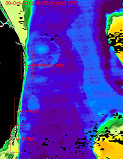
Southeast Florida USF-OOL ocean color map from a clear day in October 2012, with smaller regions of interest marked in red. A portion of Florida's mainland appears along the left edge.
Turbidity can have a significant impact on coral reef ecosystems through light limitation, sedimentation, and eutrophication. Because of the significant impact that turbidity can have, the Florida Department of Environmental Protection (FDEP) made it a priority in their 2004 local action strategy to determine the tracks and fates of turbidity in the waters of the northern Florida reef tract. Additionally, NOAA's Coral Reef Conservation Program funded a study from 2013 to 2015 to determine the feasibility of monitoring turbidity plumes in reef waters for three U.S. jurisdictions, one of which was the Southeast Florida Shelf and northern Florida reef tract. This report presents the results of that study. It shows that with care, satellite ocean color can be used to remotely monitor sources and instances of coastal ocean turbidity.
Relative turbidity or Color Index (CI) maps were gathered via the Moderate-resolution imaging spectroradiometer (MODIS) ocean color instruments on two polar-orbiting satellites at 250 meter spatial resolution. Maps have been produced for analysis from July 2002 to May 2017, and new maps have been made available to management partners in all three jurisdictions in near real-time via a public web site (https://optics.marine.usf.edu).
Citation: Gramer, L.J., and J.C. Hendee, 2018: Coastal turbidity on the southeast Florida Shelf - Monitoring turbid water sources and fates by satellite. NOAA Technical Memorandum, OAR-AOML-105 (doi:10.25923/zqv9-nw98), 31 pp.